Saint-François River
The Saint-François River is a tributary of the south shore of St. Lawrence River, flowing in the Quebec, Canada.
| Saint-François River | |
|---|---|
 A tree on the banks of the Saint-François River in Drummondville | |
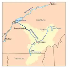 Map of the Saint-François River watershed | |
| Native name | Rivière Saint-François |
| Location | |
| Country | Canada |
| Province | Quebec |
| Region | Estrie, Chaudière-Appalaches, Centre-du-Québec |
| Cities | Sherbrooke, Drummondville |
| Physical characteristics | |
| Source | Lac Saint-François |
| • location | Lambton, Estrie, Quebec, Canada |
| • coordinates | 45°53′55″N 71°09′28″W |
| • elevation | 289 m (948 ft) |
| Mouth | |
• location | Pierreville, Centre-du-Québec, Quebec, Canada |
• coordinates | 46°07′09″N 72°55′28″W |
| Length | 218 km (135 mi) |
| Basin size | 10,230 km2 (3,950 sq mi) |
| Discharge | |
| • location | Lac Saint-Pierre |
| Discharge | |
| • location | Drummondville |
| • average | 190 m3/s (6,700 cu ft/s) |
| Basin features | |
| Tributaries | |
| • left | Magog River |
The Saint-François takes its source from Lake Saint-François in Chaudière-Appalaches, southeast of Thetford Mines. It flows southwest towards Sherbrooke, where it changes course northwest towards Drummondville, and finally empties into the Saint Lawrence River near Pierreville.
Etymology
It is named in honor of Saint Francis Xavier (1506–1552) by the Jesuits who explored the region under the French regime, and of François de Lauzon.[1]
Geography
Its course is also unusual, as it flows from northeast to southwest to branch off, halfway through, and continue its course from southeast to northwest.
The Saint-François River has its origins in the lake Saint-François and heads southwest towards Sherbrooke. Along the way, it crosses the lakes Lake Aylmer and Lake Louise as well as many municipalities.

In Sherbrooke, it receives the waters of the Massawippi River basin and the Magog River basin. It continues north-west, passing through the municipalities of Windsor, Richmond, Drummondville from there towards the Saint Lawrence River where she finishes her race, more precisely in lake Saint-Pierre.
History

The river has long been traveled by Native Americans; particularly the Abenakis. The Indian Reservation of Odanak, which today has a population of about 400, has existed since 1670. The Fort Crevier was also built in 1687 by the river. A temporary Jesuit mission was established at Coös for the Abenaki living in the Connecticut River valley or near the Kennebec River. When the Abenaki mission Saint-François-de-Sales located on the Chaudière River moved to Odanak, the village took the latter's name, "Saint-François”. Odanak is located on the banks of the Saint-François River, about 10 kilometers east of lake Saint-Pierre. In 1805, an 8,000 acre reserve (32.4 kilometres (20.13 mi)) was granted for Indian refugees in Durham Township, near the present village of L'Avenir, as well as 2,722 acres (1,102 ha) (11 kilometres (6.84 mi)) in 1853 on the shore of Petit Lac Saint-François in the township of Coleraine.[2]
References
- François de Lauzon (1635 –1647 or 1648), son of Jean de Lauzon (father)
- "Rivière Saint-François". Commission de Toponymie. 14 November 2008. Retrieved 5 November 2011.
Appendices
Related Articles
- Grand lac Saint François
- Lake Saint-François
- Lake Aylmer
- Lake Louise (Quebec)
- Lake Saint-Pierre
- List of rivers of Quebec