San Emigdio Creek
San Emigdio Creek, formerly Arroyo de San Emigdio (Spanish for Saint Emygdius Creek), is a 33 kilometres (21 mi)[2] northward-flowing stream in western Kern County, central California.
| San Emigdio Creek San Emidio Creek[1] | |
|---|---|
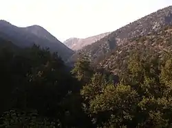 San Emigdio Creek Canyon in the San Emigdio Mountains, looking north | |
| Etymology | Spanish |
| Native name | Arroyo de San Emigdio |
| Location | |
| Country | United States |
| State | California |
| Region | Kern County |
| Physical characteristics | |
| Source | source |
| • location | Mount Pinos (northeast slopes), San Emigdio Mountains |
| • coordinates | 34°49′42″N 119°06′03″W[1] |
| • elevation | 7,000 ft (2,100 m) |
| Mouth | mouth |
• location | 4 miles southwest of Lake View (Kern County), San Joaquin Valley |
• coordinates | 35°03′31″N 119°10′49″W[1] |
• elevation | 597 ft (182 m)[1] |
Geography
The San Emigdio Creek headwaters are on the northeast slope of Mount Pinos, 2 miles (3.2 km) south of Tecuya Ridge in the San Emigdio Mountains. The creek flows north through San Emigdio Canyon to terminate 4 miles (6.4 km) southwest of Lakeview in the western San Joaquin Valley.
In years of heavy rainfall it would be a tributary to the Connecting Slough, the slough between Kern Lake and Buena Vista Lake which has been dry for decades due to agricultural diversion, pumping, and a lowering groundwater table.
History
Arroyo San Emigdio was a stream whose canyon provided the route followed by the 18th-19th century El Camino Viejo, through the San Emigdio Mountains between the Cuddy Valley and San Joaquin Valley. Its mouth provided a watering place between Cuddy Valley in the south and Arroyo de Amargosa (Bitterwater Creek) to the northwest near Buena Vista Lake.
The place where the creek emerged from the foothills of the San Emigdio Mountains was the location of Mexican land grant Rancho San Emidio of Alta California, granted in 1842 to José Antonio Dominguez.[3] The location was a rancho and station of Mission Santa Barbara as early as 1824, and the 1842 land grant continued the rancho.[4][5]
References
- U.S. Geological Survey Geographic Names Information System: San Emigdio Creek
- U.S. Geological Survey. National Hydrography Dataset high-resolution flowline data. The National Map, accessed September 7, 2011
- Mildred Brooke Hoover, Historic spots in California, Stanford University Press, Stanford, 1990, p.123
- Frank Forrest Latta, José Jesús López (1976). Saga of Rancho El Tejón. Exeter, California: Bear State Books.
- Erwin Gustav Gudde (1969). 1000 California Place Names: Their Origin and Meaning. Berkeley, California: University of California Press. p. 71. ISBN 9780520014329. Retrieved 2014-09-07.