San Sebastián barrio-pueblo
San Sebastián barrio-pueblo is a barrio and the administrative center (seat) of San Sebastián, a municipality of Puerto Rico. Its population in 2010 was 1,424.[4][5][1]
San Sebastián barrio-pueblo
Barrio Pueblo San Sebastián | |
|---|---|
Municipality Seat[1] | |
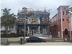 The City Hall of San Sebastián | |
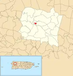 Location of San Sebastián barrio-pueblo within the municipality of San Sebastián shown in red | |
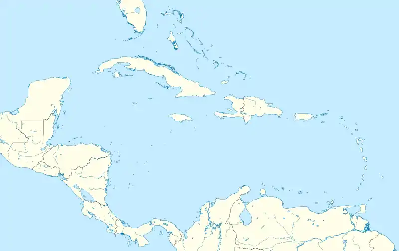 San Sebastián barrio-pueblo Location of Puerto Rico | |
| Coordinates: 18°20′12″N 66°59′24″W[2] | |
| Commonwealth | |
| Municipality | |
| Area | |
| • Total | 0.12 sq mi (0.3 km2) |
| • Land | 0.12 sq mi (0.3 km2) |
| • Water | 0 sq mi (0 km2) |
| Elevation | 253 ft (77 m) |
| Population (2010) | |
| • Total | 1,424 |
| • Density | 12,945.5/sq mi (4,998.3/km2) |
| Source: 2010 Census | |
| Time zone | UTC−4 (AST) |
As was customary in Spain, in Puerto Rico, the municipality has a barrio called pueblo which contains a central plaza, the municipal buildings (city hall), and a Catholic church. Fiestas patronales (patron saint festivals) are held in the central plaza every year.[6][7]
Description
In 2010, San Sebastián barrio-pueblo had a population of 1,424 people (decreasing from 1,952 in 2000 and 2,114 in 1990). There are two subbarrios in barrio-pueblo: Norzagaray and Urréjola.[1]
The central plaza history
The central plaza, or square, is a place for official and unofficial recreational events and a place where people can gather and socialize from dusk to dawn. The Laws of the Indies, Spanish law, which regulated life in Puerto Rico in the early 19th century, stated the plaza's purpose was for "the parties" (celebrations, festivities) (Spanish: a propósito para las fiestas), and that the square should be proportionally large enough for the number of neighbors (Spanish: grandeza proporcionada al número de vecinos). These Spanish regulations also stated that the streets nearby should be comfortable portals for passersby, protecting them from the elements: sun and rain.[6]
| Historical population | |||
|---|---|---|---|
| Census | Pop. | %± | |
| 1980 | 2,410 | — | |
| 1990 | 2,114 | −12.3% | |
| 2000 | 1,952 | −7.7% | |
| 2010 | 1,424 | −27.0% | |
| U.S. Decennial Census[8] 1899 (shown as 1900)[9] 1910-1930[10] 1930-1950[11] 1980-2000[12] 2010[13] | |||
Sectors
Barrios (which are roughly comparable to minor civil divisions)[14] in turn are further subdivided into smaller local populated place areas/units called sectores (sectors in English). The types of sectores may vary, from normally sector to urbanización to reparto to barriada to residencial, among others.[15][16][17]
The following sectors are in San Sebastián barrio-pueblo:[18]
Avenida Emérito Estrada Rivera, Calle Andrés M. Liciaga, Calle Andrés Velázquez, Calle Ángel Mislán, Calle Betances, Calle Emilio Ruiz, Calle Hipólito Castro, Calle Hostos, Calle Jesús T Piñero, Calle J. Méndez Cardona, Calle M. J. Cabrero, Calle Muñoz Rivera, Calle Padre Feliciano, Calle Pavía Fernández, Calle Raúl Gaya Benejam, Calle Ruiz Belvis, Calle Severo Arana, Calle 25 de Julio, Residencial San Sebastián Court, Residencial Villa Soigal, Sector Paralelo 38, Sector Rabo del Buey, Urbanización Guayabal, Urbanización Los Alamos, Urbanización Pedro T. Labayen, and Urbanización Román.
Cemetery
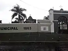
The Antiguo Cementerio Municipal de San Sebastián (old cemetery of San Sebastian) is located in barrio-pueblo. It was first used in 1826 and was completed and established in 1863.[19] The cemetery had been expanded during the cholera outbreak that occurred in Puerto Rico starting in 1855.[20]
See also
References
- Puerto Rico:2010:population and housing unit counts.pdf (PDF). U.S. Dept. of Commerce, Economics and Statistics Administration, U.S. Census Bureau. 2010.
- "US Gazetteer 2019". US Census. US Government.
- U.S. Geological Survey Geographic Names Information System: San Sebastián barrio-pueblo
- Picó, Rafael; Buitrago de Santiago, Zayda; Berrios, Hector H. Nueva geografía de Puerto Rico: física, económica, y social, por Rafael Picó. Con la colaboración de Zayda Buitrago de Santiago y Héctor H. Berrios. San Juan Editorial Universitaria, Universidad de Puerto Rico,1969.
- Gwillim Law (20 May 2015). Administrative Subdivisions of Countries: A Comprehensive World Reference, 1900 through 1998. McFarland. p. 300. ISBN 978-1-4766-0447-3. Retrieved 25 December 2018.
- Santullano, Luis A. (10 March 2019). Mirada al Caribe. 54. Colegio de Mexico. pp. 75–78. doi:10.2307/j.ctvbcd2vs.12. JSTOR j.ctvbcd2vs.12.
- Pariser, Harry S. (2003). Explore Puerto Rico, Fifth Edition. San Francisco: Manatee Press. pp. 52–55. Retrieved 10 February 2019.
- "U.S. Decennial Census". United States Census Bureau. Archived from the original on February 13, 2020. Retrieved September 21, 2017.
- "Report of the Census of Porto Rico 1899". War Department Office Director Census of Porto Rico. Archived from the original on July 16, 2017. Retrieved September 21, 2017.
- "Table 3-Population of Municipalities: 1930 1920 and 1910" (PDF). United States Census Bureau. Archived (PDF) from the original on August 17, 2017. Retrieved September 21, 2017.
- "Table 4-Area and Population of Municipalities Urban and Rural: 1930 to 1950" (PDF). United States Census Bureau. Archived (PDF) from the original on August 30, 2015. Retrieved September 21, 2014.
- "Table 2 Population and Housing Units: 1960 to 2000" (PDF). United States Census Bureau. Archived (PDF) from the original on July 24, 2017. Retrieved September 21, 2017.
- Puerto Rico:2010:population and housing unit counts.pdf (PDF). U.S. Dept. of Commerce Economics and Statistics Administration U.S. Census Bureau. 2010. Archived (PDF) from the original on 2017-02-20. Retrieved 2019-08-02.
- "US Census Barrio-Pueblo definition". factfinder.com. US Census. Archived from the original on 13 May 2017. Retrieved 5 January 2019.
- "Agencia: Oficina del Coordinador General para el Financiamiento Socioeconómico y la Autogestión (Proposed 2016 Budget)". Puerto Rico Budgets (in Spanish). Retrieved 28 June 2019.
- Rivera Quintero, Marcia (2014), El vuelo de la esperanza: Proyecto de las Comunidades Especiales Puerto Rico, 1997-2004 (first ed.), San Juan, Puerto Rico Fundación Sila M. Calderón, ISBN 978-0-9820806-1-0
- "Leyes del 2001". Lex Juris Puerto Rico (in Spanish). Retrieved 24 June 2020.
- "PRECINTO ELECTORAL SAN SEBASTIÁN 033" (PDF). Comisión Estatal de Elecciones (in Spanish). PR Government. 19 October 2018. Retrieved 19 June 2019.
- Mari Mut, José A. "Cementerios Antiguos de Puerto Rico- San Sebastián". edicionesdigitales (in Spanish).
- "EPIDEMIA Y SOCIEDAD: EFECTOS DEL CÓLERA MORBO EN PUERTO RICO Y EN COSTA RICA A MEDIADOS DEL SIGLO XIX". University of Costa Rica (in Spanish). Retrieved 10 June 2019.