Sant'Agata Feltria
Sant'Agata Feltria (Romagnol: Sant'Êgta) is a comune (municipality) in the Province of Rimini in the Italian region Emilia-Romagna, located about 125 kilometres (78 mi) southeast of Bologna and about 45 kilometres (28 mi) south of Rimini.
Sant'Agata Feltria | |
|---|---|
| Comune di Sant'Agata Feltria | |
 | |
 Coat of arms | |
Location of Sant'Agata Feltria 
| |
 Sant'Agata Feltria Location of Sant'Agata Feltria in Italy 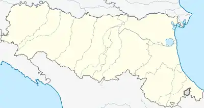 Sant'Agata Feltria Sant'Agata Feltria (Emilia-Romagna) | |
| Coordinates: 43°52′N 12°13′E | |
| Country | Italy |
| Region | Emilia-Romagna |
| Province | Rimini (RN) |
| Frazioni | Botticella, Palazzo, Pereto, Petrella Guidi, Poggio Scavolo, Rivolpaio, Rocca Pratiffi, Romagnano, Rosciano, San Donato, Sapigno, Tramonto, Ugrigno |
| Government | |
| • Mayor | Goffredo Polidori |
| Area | |
| • Total | 79.2 km2 (30.6 sq mi) |
| Elevation | 606 m (1,988 ft) |
| Population (31 December 2005)[2] | |
| • Total | 2,349 |
| • Density | 30/km2 (77/sq mi) |
| Demonym(s) | Santagatesi |
| Time zone | UTC+1 (CET) |
| • Summer (DST) | UTC+2 (CEST) |
| Postal code | 61019 |
| Dialing code | 0541 |
| Patron saint | St. Agatha |
| Saint day | February 5 |
| Website | Official website |
Overview
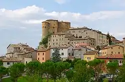
It is home to a large fortress (Fortilizio), designed, among the others, by Francesco di Giorgio Martini
History
After the referendum of 17 and 18 December 2006, Sant'Agata Feltria was detached from the Province of Pesaro and Urbino (Marche) to join Emilia-Romagna and the Province of Rimini on 15 August 2009.[3][4]
References
- "Superficie di Comuni Province e Regioni italiane al 9 ottobre 2011". Istat. Retrieved 16 March 2019.
- All demographics and other statistics: Italian statistical institute Istat.
- (in Italian) Article about the legislation Archived 2011-07-22 at the Wayback Machine
- (in Italian) Article on "il Resto del Carlino"
External links
This article is issued from Wikipedia. The text is licensed under Creative Commons - Attribution - Sharealike. Additional terms may apply for the media files.