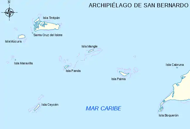
Santa Cruz del Islote
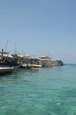
Santa Cruz del Islote (Spanish for: Santa Cruz Islet or Holy Cross Islet) is an artificial island located off the coast of Bolívar Department in Colombia, close to Tolu and Coveñas.[1][2][3] It is a part of the Archipelago of San Bernardo.[3] Its significant population, compared with its small size, results in its being one of the most densely populated islands on Earth.[4]
| Native name: Santa Cruz del Islote | |
|---|---|
 | |
| Geography | |
| Location | San Bernardo Archipelago |
| Coordinates | 9°47′9″N 75°51′33″W |
| Area | 12,140.57 m2 (130,680.0 sq ft) |
| Length | 200 m (700 ft) |
| Width | 120 m (390 ft) |
| Administration | |
| Demographics | |
| Population | 1,247 |
History
The islet is of artificial origin, built by locals who used coral, debris, stone, and other materials to build up the land at low tide. It is believed that this reclamation dates from 1870. Due to its small size, some locals would later migrate to neighboring islets such as Tintipán Island or Mucura Island.
In 2013 a community council was formed by the residents to discuss local problems.[5] The island and some residences were affected by flooding due to a tidal wave in 2018.[6]
At an event held in August 2020, attended by the Minister of Technology (ICT) of the Government of Colombia and the Governor of the Department of Bolivar, a free 24-hour Internet service called Zona Digital Rural was established for the island, allowing the residents access to distance education in the midst of the Coronavirus pandemic. Previously, service had been expensive and of poor quality, making it difficult to carry out administrative and educational activities from home.[7][2]
Geography
The island has an area of 12,140.57 m2, or almost 1.25 hectares.[8] It can be accessed by ferry from the port of Tolu. The inhabitants have to use neighboring islands as cemeteries and recreation grounds, and they work elsewhere, primarily at the Mucura Island Hotels.[4] There is one school, with one teacher.[8]
Government and politics
Due to its small size, the territory is not autonomous. Geographically it is part of the San Bernardo Archipelago in the Department of Bolivar in northern Colombia and is guarded by the Colombian Navy.[1]
References
- "Sin médico, agua ni luz enfrenta el COVID-19 una de las islas más pobladas del planeta: está en Bolívar". Noticias Caracol (in Spanish). 2020-07-03. Retrieved 2020-07-26.
- "Mintic activa Zona Digital Rural en Santa Cruz del Islote". EL HERALDO (in Spanish). Retrieved 2020-08-26.
- Rincon-Diaz, Martha Patricia; Rodríguez-Zárate, Clara Jimena (December 2004). "Characterization of nesting beaches and feeding areas of marine turtles at the San Bernardo Archipelago, Colombian Caribbean". Volume 33, Number 1. Bulletin of Marine and Coastal Research. Retrieved 9 January 2015. ISSN 0122-9761 (in Spanish)
- Wells, Miriam; Jack, Hunter (January 5, 2013), "How people live on the most crowded island on Earth", Toronto Star
- "El pequeño Manhattan del Caribe". ELMUNDO (in Spanish). 2017-09-19. Retrieved 2020-08-26.
- "Fuerte oleaje causa emergencias en Santa Cruz del Islote, Bolívar". RCN Radio (in Spanish). 2018-09-24. Retrieved 2020-08-26.
- ""Esto es histórico, Santa Cruz del Islote ya tiene internet"". EL HERALDO (in Spanish). Retrieved 2020-08-26.
- Lorena, Lucy (11 June 2013). "Un Viaje for Santa Cruz del Islote, la Isla más poblada de Colombia" [Santa Cruz del Islote, lo most densely populated island of Colombia]. El Pais (Colombia) (in Spanish).
External links
| Wikimedia Commons has media related to Santa Cruz del Islote. |