Sassafras Point Light
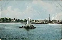
The Sassafras Point Light was a lighthouse that stood in the Providence, Rhode Island harbor approaches. It was deactivated in 1912 and no longer exists.
 postcard image of light | |
 | |

| |
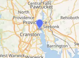
| Location | Providence River off Sassafras Point |
|---|---|
| Coordinates | 41°48′1.55″N 71°23′31.41″W[1] |
| Year first lit | 1872[2] |
| Deactivated | 1912[2] |
| Foundation | granite pier[3] |
| Construction | Wood[3] |
| Tower shape | hexagonal pyramidal tower[3] |
| Tower height | 14 feet (4.3 m)[4] |
| Focal height | 25 feet (7.6 m)[2] |
| Original lens | sixth order Fresnel lens[2] |
| Characteristic | F R |
History
This light was paired with the Fuller Rock Light from the beginning: it was approved in the same bill, built according to the same design, and tended by the same keepers.[5] Sassafras Point jutted out north into the Providence River, and the light thus marked this obstruction. The short wooden pyramidal tower sat upon a granite pier and was provided with a sixth order Fresnel lens; it was first lit in 1872.[4]
This light was unmanned and was visited from shore by boat; a keeper's dwelling was originally planned but although funds were appropriated in 1874 the lighthouse service was never able to acquire a property on which to erect a house, and keepers lived in their own homes in town. Staffing was difficult due to the low pay.[6]
The light was removed in 1912 as part of a channel-widening project.[6]
References
- Church, Earl (1920). Triangulation in Rhode Island. Government Printing Office. p. 40. Retrieved 2014-01-14.
- "Sassafras Point Lighthouse". Jeremy D'Entremont. Retrieved 2014-01-14.
- Geake, Robert A. (2013). A History of the Providence River. History Press. p. 80. Retrieved 2014-01-14.
- "Sassafras Point Lighthouse". R. Holmes. Retrieved 2014-01-14.
- "History of Fuller Rock Light, East Providence, Rhode Island". Jeremy D'Entremont. Retrieved 2014-01-14.
- "History of Sassafras Point Light, East Providence, Rhode Island". Jeremy D'Entremont. Retrieved 2014-01-14.