Schärhorn
The Schärhorn is a mountain in the Glarus Alps near Klausen Pass. The highest summit is named Gross Schärhorn (3,297 m) while a second summit is named Chli Schärhorn (3,232 m). The mountain overlooks the valley of Schächental to the north side, and the Hüfifirn to the southeast, which finally leads to the Maderanertal to the southwest. Both valleys are located in the canton of Uri.
| Schärhorn | |
|---|---|
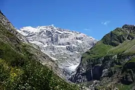 The Gross Schärhorn (white peak) and the Bocktschingelgrat to its right from the start of the Maderanertal | |
| Highest point | |
| Peak | Gross Schärhorn |
| Elevation | 3,294 m (10,807 ft) |
| Prominence | 514 m (1,686 ft) [1] |
| Parent peak | Tödi |
| Listing | Alpine mountains above 3000 m |
| Coordinates | 46°49′37″N 8°49′45″E |
| Geography | |
 Schärhorn Location in Switzerland | |
| Country | Switzerland |
| Canton | Uri |
| Parent range | Glarus Alps |
| Topo map | Swiss Federal Office of Topography swisstopo |
References
- Retrieved from the Swisstopo topographic maps. The key col is the Sandpass (2,781 m).
This article is issued from Wikipedia. The text is licensed under Creative Commons - Attribution - Sharealike. Additional terms may apply for the media files.