Schönewalde
Schönewalde is a town in the Elbe-Elster district, in southwestern Brandenburg, Germany. It is situated 30 km south of Luckenwalde, and 40 km east of Wittenberg.
Schönewalde | |
|---|---|
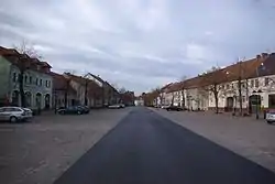 Market square | |
 Coat of arms | |
Location of Schönewalde within Elbe-Elster district  | |
 Schönewalde  Schönewalde | |
| Coordinates: 51°48′45″N 13°13′22″E | |
| Country | Germany |
| State | Brandenburg |
| District | Elbe-Elster |
| Subdivisions | 17 Ortsteile |
| Government | |
| • Mayor | Michael Stawski |
| Area | |
| • Total | 155.13 km2 (59.90 sq mi) |
| Elevation | 79 m (259 ft) |
| Population (2019-12-31)[1] | |
| • Total | 3,006 |
| • Density | 19/km2 (50/sq mi) |
| Time zone | UTC+01:00 (CET) |
| • Summer (DST) | UTC+02:00 (CEST) |
| Postal codes | 04916 |
| Dialling codes | 035362 |
| Vehicle registration | EE, FI, LIB |
| Website | www.schoenewalde.de |
Demography
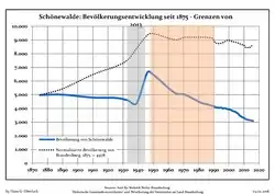 Development of population since 1875 within the current Boundaries (Blue Line: Population; Dotted Line: Comparison to Population development in Brandenburg state; Grey Background: Time of Nazi Germany; Red Background: Time of communist East Germany)
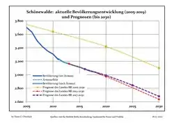 Recent Population Development and Projections (Population Development before Census 2011 (blue line); Recent Population Development according to the Census in Germany in 2011 (blue bordered line); Official projections for 2005-2030 (yellow line); for 2014-2030 (red line); for 2017-2030 (scarlet line)
|
|
|
References
- "Bevölkerung im Land Brandenburg nach amtsfreien Gemeinden, Ämtern und Gemeinden 31. Dezember 2019". Amt für Statistik Berlin-Brandenburg (in German). July 2020.
- Detailed data sources are to be found in the Wikimedia Commons.Population Projection Brandenburg at Wikimedia Commons
Towns and municipalities in Elbe-Elster | ||
|---|---|---|
| Coat of Arms of Elbe-Elster district | |
| Authority control |
|---|
This article is issued from Wikipedia. The text is licensed under Creative Commons - Attribution - Sharealike. Additional terms may apply for the media files.