Schartschrofen
The Schartschrofen is a rocky summit, 1,968 m high, in the Tannheim Mountains, a sub-group of the Allgäu Alps. It lies northwest of the Rote Flüh and south of the col of Füssener Jöchl.
| Schartschrofen | |
|---|---|
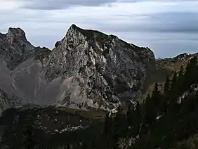 The Schartschrofen from the northeast | |
| Highest point | |
| Elevation | 1,968 m (AA) (6,457 ft) |
| Prominence | 92 m ↓ Gelbe Scharte |
| Isolation | 0.4 km → Rote Flüh |
| Coordinates | 47°30′11″N 10°36′08″E |
| Geography | |
| Parent range | Tannheim Mountains, Allgäu Alps |
| Climbing | |
| Normal route | via the Füssener Jöchl col |
Ascent
There are two waymarked paths up the Schartschrofen. The normal route runs from the valley of Tannheimer Tal via the col of Füssener Jöchl – to this point the cable car may be taken from Grän – continuing to the Hallgernjoch col and from there to the top. Along the 150-metre-high southeastern arête runs the Friedberger Klettersteig, protected throughout its length, initially leading along the ridge and then after a detour into the south flank finally climbing a gully to the summit.
Literature
- Dieter Seibert: Allgäuer Alpen Alpin Alpine Club Guide. Munich, Bergverlag Rudolf Rother, 2004. ISBN 3-7633-1126-2
- Eugen E. Hüsler: Klettersteigatlas Alpen. Munich, Bruckmann Verlag, 6th edition, 2005. ISBN 3-7654-4213-5
External links
| Wikimedia Commons has media related to Schartschrofen. |
This article is issued from Wikipedia. The text is licensed under Creative Commons - Attribution - Sharealike. Additional terms may apply for the media files.