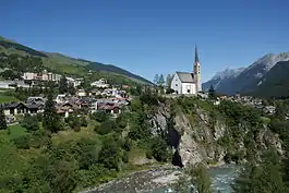
Scuol
Scuol (Romansh: [ˈʃkuɔ̯l] (![]() listen)) is a municipality in the Engiadina Bassa/Val Müstair Region in the Swiss canton of Grisons. The official language in Scuol is Romansh. On 1 January 2015 the former municipalities of Ardez, Guarda, Tarasp, Ftan and Sent merged into Scuol.[3]
listen)) is a municipality in the Engiadina Bassa/Val Müstair Region in the Swiss canton of Grisons. The official language in Scuol is Romansh. On 1 January 2015 the former municipalities of Ardez, Guarda, Tarasp, Ftan and Sent merged into Scuol.[3]
Scuol | |
|---|---|
 | |
 Coat of arms | |
Location of Scuol 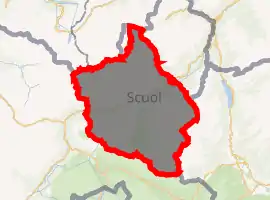
| |
 Scuol Scuol | |
| Coordinates: 46°48′N 10°17′E | |
| Country | Switzerland |
| Canton | Graubünden |
| District | Inn |
| Area | |
| • Total | 438.63 km2 (169.36 sq mi) |
| Elevation | 1,290 m (4,230 ft) |
| Population (2018-12-31)[2] | |
| • Total | 4,591 |
| • Density | 10/km2 (27/sq mi) |
| Time zone | UTC+01:00 (Central European Time) |
| • Summer (DST) | UTC+02:00 (Central European Summer Time) |
| Postal code(s) | 7550 |
| SFOS number | 3762 |
| Surrounded by | Ftan, Mals (IT-BZ), Sent, Tarasp, Tschierv, Taufers im Münstertal (IT-BZ), Valchava |
| Website | www SFSO statistics |
Name
The official name has undergone several changes in the 20th century:
- Until 1943, the official name of the municipality was Schuls.
- In 1943, it was changed to Bad Scuol/Schuls.
- In 1970 Schuls was dropped as an official name, leaving only Bad Scuol.
- In 1999 Bad was dropped, leaving today's name, Scuol.
History
Scuol is first mentioned in 1095 as Schulles.[4]
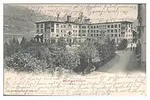
The Neo-Renaissance style Grand Hotel Waldhaus Vulpera in Scuol-Tarasp with Sgraffito-Elements was opened on 8 June 1897 and was one of the first addresses in the Swiss Alps and was a major Belle Époque monument in Europe.
Geography
After the 2015 merger Scuol had an area of 438.63 km2 (169.36 sq mi).[5] Before the merger Scuol had an area, (as of the 2004/09 survey) of 144.14 square kilometers (55.65 sq mi). Of this area, about 26.9% is used for agricultural purposes, while 25.8% is forested. Of the rest of the land, 1.2% is settled (buildings or roads) and 46.1% is unproductive land. Over the past two decades (1979/85-2004/09) the amount of land that is settled has increased by 37 ha (91 acres) and the agricultural land has decreased by 146 ha (360 acres).[6]
The whole southern face towards Piz Champatsch on 2,785 meters (9,137 ft) is being used as a skiing area called "Motta Naluns", named after a place north of Scuol. The resort has 80 kilometers of slopes and 12 lifts (aerial cableway/ chair lifts / drag lifts).
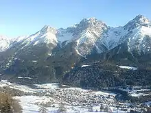
Before 2017 it was the municipality is the capital of the Inn district and was located in the Suot Tasna sub-district, after 2017 it was part of the Engiadina Bassa/Val Müstair Region. It is a well known spa town and vacation spot and is the business center of the Unterengadin valley. It is the largest village on the left side of the Inn river. It consists of the village of Scuol with the section Pradella and the old mining village of S-charl. Until 1970 Scuol was known as Scuol/Schuls.[7]
The God da Tamangur ("the forest back there") is the highest continuous stone pine forest in Europe, right at the furthest end of the Val S-charl, south of Scuol. The forest nature reserve covers an area of about 84 ha (210 acres) at up to 2,400 m (7,900 ft) in elevation. Due to the altitude and weather, the trees grow very slowly and may live up to 700 years.[8]
Demographics
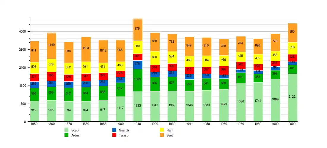
Scuol has a population (as of 31 December 2019) of 4,624.[9] As of 2008, 23.6% of the population was made up of foreign nationals.[10] Over the last 10 years the population has grown at a rate of 1.4%.[11]
As of 2000, the gender distribution of the population was 48.5% male and 51.5% female.[12] The age distribution, as of 2000, in Scuol is; 220 children or 10.4% of the population are between 0 and 9 years old. 106 teenagers or 5.0% are 10 to 14, and 139 teenagers or 6.6% are 15 to 19. Of the adult population, 248 people or 11.7% of the population are between 20 and 29 years old. 334 people or 15.7% are 30 to 39, 306 people or 14.4% are 40 to 49, and 278 people or 13.1% are 50 to 59. The senior population distribution is 201 people or 9.5% of the population are between 60 and 69 years old, 154 people or 7.3% are 70 to 79, there are 115 people or 5.4% who are 80 to 89, and there are 21 people or 1.0% who are 90 to 99.[10]
In 2013 there were 1,073 private households in Scuol. Of the 694 inhabited buildings in the municipality, in 2000, about 41.6% were single family homes and 36.6% were multiple family buildings. Additionally, about 36.5% of the buildings were built before 1919, while 11.4% were built between 1991 and 2000.[13] In 2012 the rate of construction of new housing units per 1000 residents was 20.57. The vacancy rate for the municipality, in 2014, was 2.48%.[6]
Languages
Half of the population (as of 2000) speaks Romansh (49.4%), with German being second most common (39.2%) and Italian being third ( 3.9%).[11] Scuol is host to a branch of the Lia Rumantscha.
| Languages in Scuol | ||||||
| Languages | Census 1980 | Census 1990 | Census 2000 | |||
| Number | Percent | Number | Percent | Number | Percent | |
| Romansh | 1130 | 64.79% | 1087 | 57.54% | 1049 | 49.43% |
| German | 484 | 27.75% | 651 | 34.46% | 831 | 39.16% |
| Italian | 76 | 4.36% | 77 | 4.08% | 82 | 3.86% |
| Population | 1744 | 100% | 1889 | 100% | 2122 | 100% |
Economy
As of 2012, there were a total of 2,240 people employed in the municipality. Of these, a total of 39 people worked in 13 businesses in the primary economic sector. The secondary sector employed 394 workers in 33 separate businesses. Finally, the tertiary sector provided 1,807 jobs in 265 businesses. In 2013 a total of 20.6% of the population received social assistance.[6]
Politics
In the 2011 federal election the most popular party was the BDP with 43.2% of the vote. The next three most popular parties were the SVP (20.1%), the SP (15.1%) and the FDP (10.3%). In the federal election, a total of 666 votes were cast, and the voter turnout was 46.0%.[15]
Crime
In 2014 the crime rate, of the over 200 crimes listed in the Swiss Criminal Code (running from murder, robbery and assault to accepting bribes and election fraud), in Scuol was 41.3 per thousand residents. This rate is only 63.9% of the average rate in the entire country. During the same period, the rate of drug crimes was 8.5 per thousand residents and the rate of violations of immigration, visa and work permit laws was 0.9 per thousand.[16]
Education
In Scuol about 69.7% of the population (between age 25–64) have completed either non-mandatory upper secondary education or additional higher education (either university or a Fachhochschule).[11]
Transportation
The municipality has four railway stations: Scuol-Tarasp, Ftan Baraigla, Ardez, and Guarda. All four are located on the Bever–Scuol-Tarasp line with regular service to Disentis/Mustér and Pontresina.
Hospital
There is one small regional hospital, called Ospidal Engiadina Bassa (Romansh: Hospital of the Lower Engadin). The hospital celebrated its 100th anniversary on 21 June 2008. It is one of the country's smallest hospitals, offering basic services such as departments of surgery, internal medicine, cardiology, dermatology, oncology, gynecology, a 24-hour Emergency Department, and a 2-bed intensive care unit. Understandably for a mountain resort with a major ski region, orthopedic procedures are very common.
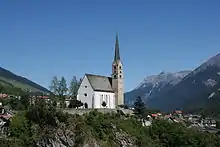
Heritage sites of national significance
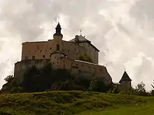
The Baselgia refurmada, the Chasa Wieland Nr. 29 and the Kurhaus Bad Tarasp (spa Bad Tarasp) in Scuol, the Chasté (a prehistoric site, a medieval fortress and a church) and the Doppelwohnhaus (Double-house) in Ardez, Tarasp Castle and the Trinkhalle (drinking hall) in Tarasp are all listed as Swiss heritage sites of national significance.[17]
The Chastè site includes settlements from the late Bronze Age (Melauner culture) into the early Iron Age (Fritzens-Sanzeno culture) as well as some finds from the Roman Empire.
The Chasa Wieland Nr.29 in Scuol village was built around a three story medieval stone tower. It was likely built by one of a few Graubünden noble families. The tower may have been damaged when Scuol was destroyed in 1499 during the Swabian War, but if so it was quickly repaired. During the Bündner Wirren, in 1622, Scuol and the tower were burned. Soon thereafter a farmhouse was built over the ruins, incorporating the 1 m (3.3 ft) thick walls. Some of the doorways are from the tower, while new windows had to be broken into the walls. The date 1753 was carved into the lintel. The walls still show the Pietra Rasa construction, where the mortar that holds the rough stones together is also used as a plaster to them. After plastering with mortar, lines are incised into the mortar to give the appearance of regular bricks or stones.[18]
Climate
Due to its geographical positioning, being located in the depth of a valley, Scuol features a warm-summer humid continental climate (Köppen: "Dfb") with moderate summers and chilly winters, which is usually accompanied with occasional snowfall. Despite seeing an average low of −8º in its coldest month, the winters here are not as cold as the towns upstream (such as St. Moritz). The town sees an average of 97.8 days of rain per year and on average receives 693 mm (27.3 in) of precipitation. The wettest month is August during which time Scuol receives an average of 96 mm (3.8 in) of precipitation. During this month there is precipitation for an average of 11.3 days. The month with the most days of precipitation is July, with an average of 11.3, but with only 87 mm (3.4 in) of precipitation. The driest month of the year is March with an average of 36 mm (1.4 in) of precipitation over 11.3 days.[19]
| Climate data for Scuol (1981–2010) | |||||||||||||
|---|---|---|---|---|---|---|---|---|---|---|---|---|---|
| Month | Jan | Feb | Mar | Apr | May | Jun | Jul | Aug | Sep | Oct | Nov | Dec | Year |
| Average high °C (°F) | −0.2 (31.6) |
2.5 (36.5) |
7.8 (46.0) |
11.9 (53.4) |
16.7 (62.1) |
20.2 (68.4) |
22.8 (73.0) |
22.1 (71.8) |
18.3 (64.9) |
13.4 (56.1) |
5.2 (41.4) |
0.0 (32.0) |
11.7 (53.1) |
| Daily mean °C (°F) | −4.5 (23.9) |
−3.2 (26.2) |
1.2 (34.2) |
5.2 (41.4) |
10.0 (50.0) |
13.0 (55.4) |
15.2 (59.4) |
14.6 (58.3) |
11.0 (51.8) |
6.6 (43.9) |
0.3 (32.5) |
−3.7 (25.3) |
5.5 (41.9) |
| Average low °C (°F) | −8.3 (17.1) |
−7.7 (18.1) |
−3.9 (25.0) |
−0.3 (31.5) |
4.1 (39.4) |
6.9 (44.4) |
9.0 (48.2) |
8.8 (47.8) |
5.6 (42.1) |
1.8 (35.2) |
−3.4 (25.9) |
−7.0 (19.4) |
0.5 (32.9) |
| Average precipitation mm (inches) | 37 (1.5) |
33 (1.3) |
36 (1.4) |
37 (1.5) |
62 (2.4) |
79 (3.1) |
91 (3.6) |
102 (4.0) |
62 (2.4) |
63 (2.5) |
61 (2.4) |
43 (1.7) |
706 (27.8) |
| Average snowfall cm (inches) | 50.6 (19.9) |
43.2 (17.0) |
20.6 (8.1) |
10.3 (4.1) |
2.2 (0.9) |
0.2 (0.1) |
0 (0) |
0 (0) |
0.2 (0.1) |
2.5 (1.0) |
28.1 (11.1) |
43.3 (17.0) |
201.2 (79.2) |
| Average precipitation days (≥ 1.0 mm) | 5.6 | 5.1 | 5.6 | 6.3 | 9.2 | 10.1 | 10.5 | 11.1 | 7.5 | 7.6 | 7.2 | 6.8 | 92.6 |
| Average snowy days (≥ 1.0 cm) | 7.7 | 6.5 | 4.9 | 3 | 0.4 | 0.1 | 0 | 0 | 0 | 0.4 | 5 | 7.4 | 35.4 |
| Average relative humidity (%) | 75 | 70 | 65 | 63 | 65 | 66 | 67 | 71 | 72 | 75 | 78 | 78 | 70 |
| Mean monthly sunshine hours | 97 | 119 | 157 | 163 | 173 | 181 | 215 | 195 | 165 | 144 | 93 | 77 | 1,779 |
| Source: MeteoSwiss [20] | |||||||||||||
Notable people
- Felix Calonder, Swiss politician
- Tonia Maria Zindel, Swiss actress
References
- "Arealstatistik Standard - Gemeinden nach 4 Hauptbereichen". Federal Statistical Office. Retrieved 13 January 2019.
- "Ständige Wohnbevölkerung nach Staatsangehörigkeitskategorie Geschlecht und Gemeinde; Provisorische Jahresergebnisse; 2018". Federal Statistical Office. 9 April 2019. Retrieved 11 April 2019.
- Amtliches Gemeindeverzeichnis der Schweiz published by the Swiss Federal Statistical Office (in German) accessed 27 April 2016
- Scuol in German, French and Italian in the online Historical Dictionary of Switzerland.
- Arealstatistik Standard - Gemeindedaten nach 4 Hauptbereichen
- Swiss Federal Statistical Office – Regional portraits accessed 2 May 2016
- Amtliches Gemeindeverzeichnis der Schweiz published by the Swiss Federal Statistical Office (in German) accessed 23 September 2009
- "God da Tamangur - Wanderland". www.schweizmobil.ch. nd. Retrieved 6 April 2020.
- "Ständige und nichtständige Wohnbevölkerung nach institutionellen Gliederungen, Geburtsort und Staatsangehörigkeit". bfs.admin.ch (in German). Swiss Federal Statistical Office - STAT-TAB. 31 December 2019. Retrieved 6 October 2020.
- Graubunden Population Statistics Archived 27 August 2009 at the Wayback Machine (in German) accessed 21 September 2009
- Swiss Federal Statistical Office accessed 12 October 2009
- Graubunden in Numbers Archived 24 September 2009 at the Wayback Machine (in German) accessed 21 September 2009
- Swiss Federal Statistical Office STAT-TAB – Thema 09 – Bau- und Wohnungswesen (in German) accessed 5 May 2016
- Swiss Federal Statistical Office STAT-TAB Bevölkerungsentwicklung nach institutionellen Gliederungen, 1850–2000 (in German) accessed 27 April 2016
- Swiss Federal Statistical Office – Nationalratswahlen 2011: Parteistärken, Wahlbeteiligung, fiktive Wählende Archived 14 November 2013 at the Wayback Machine (in German) accessed 2 May 2016
- Statistical Atlas of Switzerland accessed 5 April 2016
- Swiss inventory of cultural property of national and regional significance Archived 1 May 2009 at the Wayback Machine 21 November 2008 version, (in German) accessed 12 October 2009
- "Tuor". www.burgenwelt.ch. Retrieved 17 April 2017.
- "Temperature and Precipitation Average Values-Table, 1961–1990" (in German, French, and Italian). Federal Office of Meteorology and Climatology – MeteoSwiss. Archived from the original on 27 June 2009. Retrieved 8 May 2009., the weather station elevation is 1303 meters above sea level.
- "Climate Norm Value Tables". Climate diagrams and normals from Swiss measuring stations. Federal Office of Meteorology and Climatology (MeteoSwiss). Archived from the original on 14 May 2013. Retrieved 23 January 2013. The weather station elevation is 1303 meters above sea level.
External links
| Wikimedia Commons has media related to Scuol. |
- Cumün da Scuol
- Scuol in German, French and Italian in the online Historical Dictionary of Switzerland.