Seiland
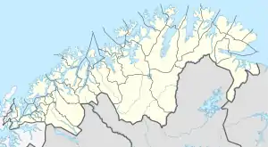
Seiland (Northern Sami: Sievju) is the eighth largest island in mainland Norway, located in Troms og Finnmark county. The 583-square-kilometre (225 sq mi)[2] island is divided between the municipalities of Alta and Hammerfest[3][4]
| Native name: Sievju | |
|---|---|
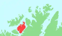 | |
 Seiland Location of the island  Seiland Seiland (Norway) | |
| Geography | |
| Location | Troms og Finnmark, Norway |
| Coordinates | 70.42°N 23.24°E |
| Area | 583 km2 (225 sq mi) |
| Highest elevation | 1,078 m (3537 ft) |
| Highest point | Seilandstuva |
| Administration | |
Norway | |
| County | Troms og Finnmark |
| Municipalities | Alta and Hammerfest |
| Demographics | |
| Population | 147[1] (2013) |
| Pop. density | 0.3/km2 (0.8/sq mi) |
Archeological excavations have shown that people have lived on Seiland for over 7000 years. Today, however the only people on it live in a few relatively isolated areas such as from Altneset to Hakkstabben on the southern tip of the island; Kårhamn on the northwestern side; and the Hønseby, Eidvågen, Fiskebukta, Survika areas in the northern part of the island. In 2006, the majority of central Seiland was designated as Seiland National Park.
There are two glaciers on Seiland: Seilandsjøkelen and Nordmannsjøkelen. The 1,078-metre (3,537 ft) tall Seilandstuva is the tallest mountain on the island. There are a number of fjords located on the island including Lille Kufjorden, Store Kufjorden, Nordefjorden, and Jøfjorden.[5]
See also
References
- https://snl.no/Seiland
- "Statistisk årbok 2009: Geografisk oversikt" (in Norwegian). Ssb.no. Retrieved 2010-08-01.
- "Seiland". Retrieved 5 Aug 2010.
- "Seiland National Park". VisitNorway.com. Archived from the original on 2011-09-28. Retrieved 5 Aug 2010.
- Store norske leksikon. "Seiland" (in Norwegian). Retrieved 2013-01-15.