Seine River (Manitoba)
The Seine River (French: Rivière Seine) is a tributary of the Red River of the North that runs through southeastern Manitoba, Canada. It is one of the four rivers of the city of Winnipeg.
| Seine River | |
|---|---|
 La Coulée River is a tributary of the Seine River | |
 | |
| Location | |
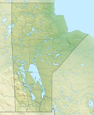
| Country | Canada |
| Province | Manitoba |
| Physical characteristics | |
| Source | Marchand, Manitoba area |
| • coordinates | 49°25′00″N 96°27′37″W |
| • elevation | 302 m (991 ft) |
| Mouth | Red River of the North |
• location | Saint Boniface, Winnipeg, Manitoba |
• coordinates | 49°54′00″N 97°06′36″W |
• elevation | 226 m (741 ft) |
| Basin size | 2,509 km2 (969 sq mi)[1] |
Its name comes from the Aboriginal word Tchimâhâgânisipi from Tchimâhâgân (meaning draw net or seine net) and sipi (river). The river rises in the Sandilands Provincial Forest near Steinbach and passes by or through the communities of Marchand, La Broquerie, Ste. Anne, and Lorette before reaching the Red River Floodway near the Winnipeg city limits.[2] At this point the river's channel is diverted under the Floodway into what is known as the "Seine River Siphon", which allows a flow of up to 4.5 cubic metres per second (160 cu ft/s); any additional flow is diverted onto the Floodway. During a wet spring, the river often overflows its banks, sometimes flooding nearby houses. During a dry summer, the river is often reduced to a trickle.
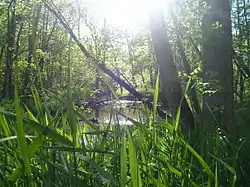
Within the city, the Seine travels a tortuously meandering course, reaching the Red River at St. Boniface just north of The Forks. The lower section of its course in the city marks the east–west boundary between the southern section of St. Boniface and the suburb of St. Vital. It is a typical meandering river with a single main channel embanked within a flat, shallow valley. The river's banks are heavily treed, but pollution has been an issue in the city of Winnipeg.
See also
References
- "Seine River Watershed". Seine Rat Roseau Watershed District. Retrieved 2020-12-30.
- River description. Archived 2010-06-07 at the Wayback Machine
External links
| Wikimedia Commons has media related to Seine River (Manitoba). |
- Save Our Seine Environment Inc.
- Rivière Seine. Ressources naturelles Canada (fr). Retrieved 6 January 2017.