Selle (Somme tributary)
The Selle (also spelt Celle in the Oise) is a river of Hauts-de-France, France. It is 39.2 km (24.4 mi) long.[1] Rising at Catheux, just north of Crèvecœur-le-Grand, Oise, it flows past Conty, Saleux, Salouël and Pont-de-Metz before joining the Somme at Amiens.
| The Selle | |
|---|---|
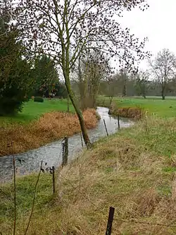 The Selle (or Celle) at Croissy-sur-Celle | |
.png.webp) | |
| Location | |
| Country | France |
| Physical characteristics | |
| Source | |
| • location | Catheux |
| Mouth | Somme |
• location | Amiens |
• coordinates | 49°54′25″N 2°16′50″E |
| Length | 39 km (24 mi) |
| Basin size | 610 km2 (240 sq mi) |
| Discharge | |
| • average | 4.5 m3/s (160 cu ft/s) |
| Basin features | |
| Progression | Somme→ English Channel |
In many places along its course, the river widens to form or fill lakes, much appreciated by anglers and gravel extractors. Several water-powered mills can still be seen including a paper-mill at Prouzel. Brown trout thrive in the clear waters of the river.
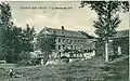 The watermill between Fontaine-Bonneleau and Croissy-sur-Celle
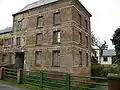 The Mill at Croissy-sur-Celle
References
External links
| Wikimedia Commons has media related to Selle river. |
- Page about the Selle on the website of the Canton de Conty (in French)
- Banque Hydro - Station E6426010 - La Selle à Plachy-Buyon (option Synthèse) (in French)
- http://www.geoportail.fr
Notes
- This article is based on the equivalent article from the French Wikipedia, consulted on February 20, 2008.
This article is issued from Wikipedia. The text is licensed under Creative Commons - Attribution - Sharealike. Additional terms may apply for the media files.