Sem, Ariège
Sem is a former commune in the Ariège department in southwestern France. On 1 January 2019, it was merged into the new commune Val-de-Sos.[2]
Sem | |
|---|---|
Part of Val-de-Sos | |
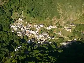 An aerial view of Sem | |
Location of Sem 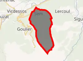
| |
 Sem  Sem | |
| Coordinates: 42°46′07″N 1°31′11″E | |
| Country | France |
| Region | Occitanie |
| Department | Ariège |
| Arrondissement | Foix |
| Canton | Sabarthès |
| Commune | Val-de-Sos |
| Area 1 | 5.22 km2 (2.02 sq mi) |
| Population (2017)[1] | 23 |
| • Density | 4.4/km2 (11/sq mi) |
| Time zone | UTC+01:00 (CET) |
| • Summer (DST) | UTC+02:00 (CEST) |
| Postal code | 09220 |
| Elevation | 825–2,042 m (2,707–6,699 ft) (avg. 960 m or 3,150 ft) |
| 1 French Land Register data, which excludes lakes, ponds, glaciers > 1 km2 (0.386 sq mi or 247 acres) and river estuaries. | |
Geography and sights
The Sem village lies in the Vicdessos valley at 991 meters above sea level. It is an old mining village, tied with the history of the iron mining of Rancié. The stream of Sem forms a huge waterfall (Carraoucou waterfall) and a cone. A big rock called "the dolmen" of Sem was made by a former glacier.
Population
Inhabitants of Sem are called Sémois.
| Year | Pop. | ±% |
|---|---|---|
| 1962 | 6 | — |
| 1968 | 13 | +116.7% |
| 1975 | 17 | +30.8% |
| 1982 | 16 | −5.9% |
| 1990 | 14 | −12.5% |
| 1999 | 19 | +35.7% |
| 2008 | 29 | +52.6% |
See also
References
- Téléchargement du fichier d'ensemble des populations légales en 2017, INSEE
- Arrêté préfectoral 16 July 2018, p. 160 (in French)
| Wikimedia Commons has media related to Sem, Ariège. |
This article is issued from Wikipedia. The text is licensed under Creative Commons - Attribution - Sharealike. Additional terms may apply for the media files.