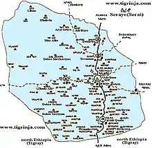
Serae
Serae ሰራየ (or Seraye) is a former province of Eritrea which had an estimated population of 515,000 in 1990 (the most populous province) and an area of 7,100 km2 (2,700 sq mi).[1][2]. The province is home to three of the Eritrean ethnic groups namely the Tigrinyas, Tigre, and Saho. It has since been incorporated primarily into the Debub Region, though some western districts have become part of the Gash-Barka Region. It is believed that the name of the province is from the "dark forests" which once thrived on its fertile ground.[3]
Today the region is home to twelve monasteries of the Eritrean Orthodox Church as well as a number of new factories in the town of Mendefera.
Districts
- Medri Wedi'Sebera ምድሪ ወዲ ሰበራ
- Tsilima ጽልማ
- Debub ደቡብ
- GuH'tsi'A ጉሕጭዓ
- Mai Tsa'eda ማይጻዕዳ/ ማጫዕዳ
- Enda Azmach Oqbit እንዳዝማች ዑቕቢት
- Deqi Bokhri ደቂ ቦኽሪ
- Meraguz መራጉዝ
- QoHain ቆሓይን
- Gundet ጒንደት
- Aila ዓይላ
- Sef'a ሰፍኣ
- Harfe Gurotto ሃርፈጒረቶ
- Deqi Digna ደቂ ድግና
- Deqi Aites ደቂ ጣዒስ
- Dembelas ደምበላስ
- Zaide'kolom ዛይደ'ኮሎም
- Anagir ዓናግር
- Tekela ተኸላ
- Kuno Redae ኲኖ ረዳእ
- Etan Zere ዕጣን ዘርአ
- Misyam ምስያም
- Medri Felasi ምድሪ ፈላሲ
- Timzea - ትምዝኣ
History
Serae/ Seraye (Tigrigna:Tigre:Geez ሰራየ) is an ancient entity which was a region of the Kingdom of D'mt[4] , which would evolve in the Kingdom of Aksum and later the center of the kingdom of Medri Bahri centered in Debarwa with its leaders Bahri Negasi.[5] Seraye was bound by regions of Akele Guzay in the east, Hamassien in the North, Tigray proper( Adwa፡shire፡Axum) in the south and Gash-Setit in the west During this Axumite period, the region became a successful trading region as it lay between the Red Sea port of Adulis, Asmara, and Axum.
In his tablet, Ezana mentions several peoples he had subjugated and refers to himself as the ruler of Aksum, Himyar, Sheba (Saba') and Rydan in Yemen. He also mentions 'Sarawi' as one of the people he subjugated. Furthermore he mention that he subjugated the king of 'Sarati', (this name crops up in different forms of one of which is Sarawi. It stands for the Eritrean province of 'Serae'), and says that he came to an understanding with him concerning the passage of trade caravans to 'Adulis' peacefully across his country. However, the names of these kingdoms disappeared after the fourth century A.D. Following the fall of Aksum as a united kingdom after the Hamiti Beja tribes overran the Eritrean highlands in the 8th century A.D., the province Seraye formed an independent state under the administration of its ruler who was called 'Cantibai'. [6]
Seraye appears on indigenous maps of the northern Horn of Africa in the 15th Century.[7][8]
Bahri Negasi existed until the 1600s. The province had its own written native administration codes that was used from the beginning of the 1400AD, which was named as the law of Adkeme-Miligae. The book existed until the come of the anti Christian jihadist Ahmad Gragn in the 1600s, burning churches and killing the believers and progressing northwards from present-day eastern Ethiopia or around Somalia, and the book was lost/burnt at that time. The people of Seraye were administered without the book verbally until the come of the Italians in the end of the 19th century. In 1938 again the book of native law code was written of elderly and knowledgeable people from 7 villages (Adi Mongonti, Mayduma, Kudo Felasi , Bet Gabriel, Qine Hayela, Adi Hyis, and May Leham) representing the whole awraja Seraye except the Logo Tchiwa which had its own codes in addition to the Adkeme-Miligae. This Law had more liberal customs and low restrictions on women's rights for land ownership than any other laws in the country.[9]
Despite the Emperor of Ethiopia's allegations and grants of control of the country of the Bahri negesitat the Zagwe and Solomonic dynasties, the 1984 "Proceedings of the Permanent Peoples' Tribunal of the International League for the Rights and Liberation of Peoples," declares that "There was no administration that connected Serae and Hamasin to the centre of the Ethiopian Kingdom.[10] Most of Seraye and Akeleguzay are together now inside the Southern region of Eritrea.
References
- Kurt, Hanevik, Eritrean amputee statistics
- Adugna, Aynalem(1984) The spatial pattern in the Ethiopian population, p.200, Durham theses, Durham University
- Killion, Tom (1998). Historical Dictionary of Eritrea. The Scarecrow Press. ISBN 0-8108-3437-5.
- , History of Eritrea,Old Races In Eritrea, Written by Othoman Saleh Sabe, translated by Muhamad Fawaz al-Azem. Published 1970 by Dar al-Masirah in Beirut, Lebanon, p19
- Yohannes Mekonnen 2013, Ethiopia the Land, Its People, History and Culture, pp 351.ISBN 1482311178, 9781482311174
- Sabbe, O.Saleh, History of Eritrea, translated by Muhamad Fawaz al-Azem. Published 1970 by Dar al-Masirah in Beirut, Lebanon, p30
- Nyssen, J., Tesfaalem Ghebreyohannes, Hailemariam Meaza, Dondeyne, S., 2020. Exploration of a medieval African map (Aksum, Ethiopia) – How do historical maps fit with topography? In: De Ryck, M., Nyssen, J., Van Acker, K., Van Roy, W., Liber Amicorum: Philippe De Maeyer In Kaart. Wachtebeke (Belgium): University Press: 165-178.
- Smidt W (2003) Cartography, in: Uhlig S (ed.): Encyclopaedia Aethiopica, Wiesbaden: Harrassowitz, vol. 1: 688-691
- UN, FAO, Gender and Land Rights Database, Eritrea
- "Proceedings of the Permanent Peoples' Tribunal of the International League for the Rights and Liberation of Peoples". Session on Eritrea. Rome, Italy: Research and Information Centre on Eritrea. 1984.