Serra Mariola Natural Park
The Serra Mariola Natural Park[1] (Valencian pronunciation: [ˈsɛra ðe maɾiˈɔla], Spanish: Parque Natural de la Sierra de Mariola) is a mountain range in the Valencian Community, Spain, one of the most peripheral offsprings of the Baetic System. Most of its territory is included in a natural park founded in 2002, covering an area of 17,257 ha.
| Serra de Mariola Natural Park | |
|---|---|
| Parque Natural de la Sierra de Mariola (in Spanish) | |
IUCN category IV (habitat/species management area) | |
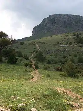 Path to the Montcabrer 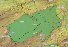 Map of the Serra Mariola Natural Park | |
| Location | Alcoy, Valencian Community, Spain |
| Nearest city | Valencian Community: Alcoy, Cocentaina, Muro de Alcoy, Agres, Alfafara, Bocairent and Banyeres de Mariola. |
| Coordinates | 38°44′1″N 0°35′30″W |
| Area | 17.257 ha |
| Established | 2002 |
| Governing body | Generalitat Valenciana |
It has a rectangular shape and altitudes higher than 1,000 metres, the highest peak being the Montcabrer, at 1,389 metres high. To the north the Benicadell Mountain Range has a peak bearing the same name and is 1,104 metres high. The Serra is predominantly composed of limestone. The climate is largely Mediterranean.
Covering these mountain ranges are some 200 or more different aromatic and medicinal plants with hundreds of different trees, which include a variety of yew unique to this area.
References
- Juan Picó & Enrique A. Moltó. (2006). "Geografia física" in Història d'Alcoi. (p. 35). Alcoi: Ajuntament d'Alcoi, Editorial Marfil, S.A., Centre Alcoià d'estudis Històrics i Arqueològics. ISBN 84-89136-50-5
See also
External links
| Wikimedia Commons has media related to Serra Mariola Natural Park. |
- Serra Mariola Natural Park (Spanish, Valencian)