Sgùrr an Airgid
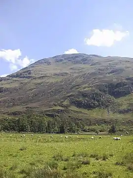
Sgurr an Airgid (841 m) is a mountain in the Northwest Highlands, Scotland. It lies on the northern shore of Loch Duich in Kintail.
| Sgurr an Airgid | |
|---|---|
 Sgurr an Airgid | |
| Highest point | |
| Elevation | 841 m (2,759 ft) [1] |
| Prominence | 394 m (1,293 ft) |
| Listing | Corbett, Marilyn |
| Coordinates | 57°14′55″N 5°24′57″W |
| Geography | |
| Location | Ross and Cromarty, Scotland |
| Parent range | Northwest Highlands |
| OS grid | NG940227 |
| Topo map | OS Landranger 25, 33 |
Although the mountain is lower in height than many of its neighbours, it still offers excellent views from its summit. The path zig zags up to the top. The nearest main village is Dornie.[2]
References
- "Sgurr an Airgid". hill-bagging.co.uk. Retrieved 9 May 2019.
- "walkhighlands Sgurr an Airgid". walkhighlands.co.uk. Retrieved 9 May 2019.
This article is issued from Wikipedia. The text is licensed under Creative Commons - Attribution - Sharealike. Additional terms may apply for the media files.