Shakotan Peninsula
The Shakotan Peninsula (積丹半島, Shakotan hantō) in Shiribeshi, on the west coast of Hokkaidō, Japan, is a mountainous peninsula which projects some 30 kilometres (19 mi) into the Sea of Japan. The Shakotan Peninsula forms part of the Niseko-Shakotan-Otaru Kaigan Quasi-National Park.[1]
| Shakotan Peninsula | |
|---|---|
| Shakotan-hantō | |
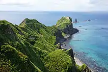
 Cape Shakotan, Shakotan Peninsula | |
| Location | Shiribeshi Subprefecture, Hokkaido Prefecture, Japan |
| Highest point – elevation – coordinates | Mount Shakotan 1,255 m (4,117 ft) 43°16′14″N 140°28′49″E |
| Length | 30 m (98 ft) |

Geography
The peninsula has a rugged terrain with few level areas. The coastline of the peninsula suffers from extensive marine erosion, which resulted in the numerous natural stone pillars which project from the sea.[2] Mount Shakotan (1,255 metres (4,117 ft)) forms the highest peak on the peninsula. The peninsula has numerous scenic capes and inlets, notably Cape Shakotan and Cape Kamui.[3]
Economy
The area was once a thriving center of Pacific herring fishing, which was conducted from the villages of Furubira, Iwanai, and Yoichi.[1]
See also
- Kamuimisaki (神威岬):Northwest point
References
- "Shakotan Peninsula". Encyclopedia of Japan. Tokyo: Shogakukan. 2012. OCLC 56431036. Archived from the original on 2007-08-25. Retrieved 2012-07-12.
- "積丹半島" [Shakotan Peninsula]. Dijitaru Daijisen (in Japanese). Tokyo: Shogakukan. 2012. OCLC 56431036. Archived from the original on 2007-08-25. Retrieved 2012-07-12.
- "積丹半島" [Shakotan Peninsula]. Nihon Kokugo Daijiten (in Japanese). Tokyo: Shogakukan. 2012. OCLC 56431036. Archived from the original on 2007-08-25. Retrieved 2012-07-12.