Shoemaker River
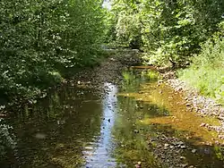
The Shoemaker River is an 11.6-mile-long (18.7 km)[1] river in the U.S. state of Virginia. It is a tributary of the North Fork Shenandoah River in Rockingham County, flowing along the western base of Little North Mountain. The river's elevation decreases about 230 feet from the source to the mouth.
| Shoemaker River | |
|---|---|
 | |
| Location | |
| Country | United States |
| Physical characteristics | |
| Source | |
| • location | Long Run (1330 Feet), Hogpen Run, Slate Lick Branch, and Turner Run |
| Mouth | |
• coordinates | 38°38′21″N 78°53′16″W |
• elevation | 1,100 ft (340 m) |
| Length | 11.6 mi (18.7 km) |
See also
References
- U.S. Geological Survey. National Hydrography Dataset high-resolution flowline data. The National Map, accessed August 15, 2011
- U.S. Geological Survey Geographic Names Information System: Shoemaker River
- USGS Hydrologic Unit Map - State of Virginia (1974)
- Salmon, Emily J.; Edward D. C. Campbell, Jr., eds. (1994). The Hornbook of Virginia History (4th ed.). Richmond, VA: Virginia Office of Graphic Communications. ISBN 0-88490-177-7.
This article is issued from Wikipedia. The text is licensed under Creative Commons - Attribution - Sharealike. Additional terms may apply for the media files.