Shore lead
A shore lead (or coastal lead) is an oceanographic term for a waterway opening between pack ice and shore. While the gap of water[1] may be as narrow as a tide crack if closed by wind or currents, it can be as wide as 1,000 feet (300 m).[2] Its formation can be influenced by tidal action, or subsurface conditions, such as current and ocean floor.[2] Commonly, a shore lead is navigable by surface vessels.[3]
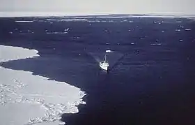
NOAA Ship Surveyor in 1977.
An opening ("lead") between pack ice and fast ice is referred to as a flaw lead.[3]
References
- "Annual Ice". eoearth.org. Retrieved 2008-10-30.
- Aufderheide, A.C.; Pitzl, G. (1968). "Observations on Ice Regions of the Arctic Ocean" (PDF). Arctic. ucalgary.ca. 23 (2): 135, 136. doi:10.14430/arctic3166. ISSN 0066-6963. OCLC 183414927.
- "Lead". dbcp.noaa.gov. Archived from the original on 2009-01-08. Retrieved 2008-10-30.
This article is issued from Wikipedia. The text is licensed under Creative Commons - Attribution - Sharealike. Additional terms may apply for the media files.