Simi Peak
Simi Peak is the highest peak in the Simi Hills of Southern California, at 2,405 feet (733 m).
| Simi Peak | |
|---|---|
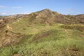 The 2,276 ft (694 m) western summit of Simi Peak | |
| Highest point | |
| Elevation | 2,405 ft (733 m) NAVD 88[1] |
| Prominence | 816 ft (249 m) [2] |
| Coordinates | 34°12′16″N 118°46′51″W [1] |
| Geography | |
 Simi Peak | |
| Location | Ventura County California, U.S. |
| Parent range | Simi Hills |
| Topo map | USGS Thousand Oaks |
Geography
Simi Peak is located in eastern Ventura County, California, near the cities of Simi Valley to the north, and Thousand Oaks to the west.
Nearby peaks
Chatsworth Peak is a peak that is also located in Simi Hills, on the far eastern edge. Escorpión Peak (Castle Peak) is closer in the hills, at 1,475 feet (450 m) and located in El Escorpión Park to the east.
Parks; and recreation
The peak is in the Cheeseboro and Palo Comado Canyons Open Space park, part of the NPS Santa Monica Mountains National Recreation Area system. Simi Peak is accessible by trail, with trailheads in the towns of Simi Valley, Thousand Oaks, and Agoura Hills, and by trails connecting from the Upper Las Virgenes Canyon Open Space Preserve.[3][4]
See also
- Index: Simi Hills
References
- "Simi Reset". NGS data sheet. U.S. National Geodetic Survey. Retrieved 2009-07-15.
- "Simi Peak, California". Peakbagger.com. Retrieved 2014-12-29.
- NPS Cheeseboro—Palo Comado access date: 2010-05-28
- L.A.Mountains official Upper Las Virgenes Canyon Park. access date: 2010-05-28
External links
| Wikimedia Commons has media related to Cheeseboro and Palo Comado Canyons Open Space. |
- NPS Cheeseboro—Palo Comado — Official Cheeseboro Canyon—Palo Comado Canyon Park website
- L.A.Mountains Cheeseboro Canyon Park information
- L.A.Mountains official Upper Las Virgenes Canyon Park website.
- Ventura County Trails.org Simi Hills Preserves trails website.
- Upper Las Virgenes Canyon - Park Geology information