Sinirname
A Sınırname was a type of document in the Ottoman empire, representing an area of land;[1] similar to a modern title deed, although often describing a larger area such as a village or district, rather than a single residence.[2]
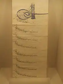
A sınırname for the village of Subaşı, in Hayrabolu district, in eastern Thrace; which was mülk (freehold) land belonging to Rüstem Pasha. The top of the "sınırname" is signed with the imperial tughra.
A sınırname would be granted by a higher authority - even the sultan. It would describe the boundary of the land.[3] A sınırname might be issued like a land grant, or it might be issued following resolution of a border dispute[4] (for instance, by a kadi).
Sınırname also described land usage; they were parallel to the system of defters which were used for taxation.[5]
References
- YOMRALIOĞLU; BIYIK. "Land Information Systems in 1500s" (PDF). FIG.XX International Congress: 5. Retrieved 28 October 2012. Cite journal requires
|journal=(help) - Glossary.doc "Glossary" Check
|url=value (help). ISLAM, LAND & PROPERTY RESEARCH SERIES. UN Habitat. Retrieved 28 October 2012. - Parveva (June 2010). Village, town and people in the Ottoman Balkans: 16th-mid-19th century. p. 12. ISBN 9781617190988.
- Archivum Ottomanicum. 24–25: 44. Missing or empty
|title=(help) - Keyder, Caglar; Keyder, Ça?lar; Tabak, Faruk (1991). Landholding and Commercial Agriculture in the Middle East. p. 20. ISBN 9780791405505.
This article is issued from Wikipedia. The text is licensed under Creative Commons - Attribution - Sharealike. Additional terms may apply for the media files.