Siriyari
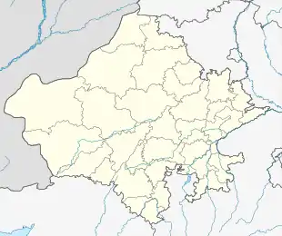
Siriyari is a small town situated in State of Rajasthan, District Pali. It is situated on State Highway 62 connecting Sojat, Sojat Road, Sireeyari, Phulad, Jojawar. This village has a police station connected to nearby villages via Chowkis thereof.
Siriyari | |
|---|---|
Village | |
 Siriyari Location in Rajasthan, India  Siriyari Siriyari (India) | |
| Coordinates: 25.673261°N 73.808352°E | |
| Country | |
| State | Rajasthan |
| District | Pali |
| Government | |
| • Body | Gram Panchayat |
| Population (2001) | |
| • Total | 13,500 |
| Languages | |
| • Official | Hindi |
| Time zone | UTC+5:30 (IST) |
| PIN | 306027 |
| Telephone code | 02935 |
| Vehicle registration | RJ-22 |
| Sex ratio | 993 ♂/♀ |
It is famous as death place of Acharya Bhikshu (1726–1803) who was the founder and first spiritual head of the Shwatambar Terapanth sect of Jainism. There is a famous temple on his name, which has been a new landmark.[1]
History
This is a leading estate established by the Kumpawat clan of Rathores in 1635. Thakur Mahesh Das, son of Rao Kumpa of Marwar, was father of a son, Thakur Aas Karan, who was granted the estate of Digai in 1616. His eldest son, Thakur Amar Singh succeeded in Digai and won Siriyari from the Solanki Rajputs in a battle in 1635.[2]
Connectivity
District Headquarter: Pali (74 km) Nearest Railway Station: Sojat Road (24 km) and Marwar Junction Buses are available all time from Sojat Road which is best spot for getting via Roads.
References
- "Bhikshu".
- History. "Rajput History".
- Shashi, S. S. Encyclopaedia Indica: India, Pakistan, Bangladesh. Origin and development of Indus civilization (Volume 1). Anmol Publications. ISBN 81-7041-859-3.
- Singh, Narendra (2001). "Acahrya Bhikshu and Terapanth". Encyclopaedia of Jainism. Anmol Publications. ISBN 81-261-0691-3.