Sistranda
Sistranda is the administrative centre of the municipality of Frøya in Trøndelag county, Norway. The village is located on the east side of the island of Frøya, about 4 kilometres (2.5 mi) north of the village of Hammarvika and the entrance to the Frøya Tunnel. The 1.04-square-kilometre (260-acre) village has a population (2018) of 1,041 and a population density of 1,001 inhabitants per square kilometre (2,590/sq mi).[1]
Sistranda | |
|---|---|
Village | |
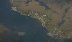 View of the village | |
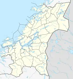 Sistranda Location of the village  Sistranda Sistranda (Norway) | |
| Coordinates: 63.7252°N 08.8332°E | |
| Country | Norway |
| Region | Central Norway |
| County | Trøndelag |
| District | Fosen |
| Municipality | Frøya |
| Area | |
| • Total | 1.04 km2 (0.40 sq mi) |
| Elevation | 12 m (39 ft) |
| Population (2018)[1] | |
| • Total | 1,041 |
| • Density | 1,001/km2 (2,590/sq mi) |
| Time zone | UTC+01:00 (CET) |
| • Summer (DST) | UTC+02:00 (CEST) |
| Post Code | 7260 Sistranda |
Sistranda has schools representing all levels up to high school. It is also the centre of transportation on the island of Frøya, with buses to locations around the region and ferries with daily routes to Trondheim, Mausund, Sula, and Froan.
Name
The first element is the name of an old farm (Old Norse: Síða). The name of the farm is identical with the word síða which means "side" (here in the sense of the "coast"). The farm is today divided in three parts: Yttersian (Outer-Sian), Midtsian (Middle-Sian) and Innersian (Inner-Sian). The last element is the finite form of strand.[3]
References
- Statistisk sentralbyrå (1 January 2018). "Urban settlements. Population and area, by municipality".
- "Sistranda, Frøya (Trøndelag)". yr.no. Retrieved 2018-02-19.
- Rygh, Oluf (1901). Norske gaardnavne: Søndre Trondhjems amt (in Norwegian) (14 ed.). Kristiania, Norge: W. C. Fabritius & sønners bogtrikkeri. p. 58.