Skaručna Basin
The Skaručna Basin (pronounced [skaˈɾuːtʃna]; Slovene: Skaruško polje) is part of the Ljubljana Basin in Slovenia.[1]
Geography
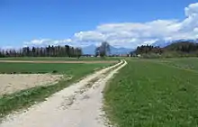
The Skaručna Basin has a characteristic mixed cultural landscape, with meadows, tilled fields, pastures, watercourses, vegetation corridors, hedgerows, isolated hills, and settlements on the edge of the floodplain.[2] Graben Creek starts at Loess Pond (Slovene: Phliški bajer or Puhliški bajer,[3] also known as Koseze Pond, Koseški bajer[4]) in the northeast part of the basin; the pond is a former clay pit created about 200 years ago where ice was also harvested until the First World War.[4] Graben Creek runs along the southeast edge of the basin, fed by Brodnek Spring, Smrekar Spring (Slovene: Smrekarjev studenec), and Štefan Spring (Slovene: Štefanov studenec) The basin includes the settlements of Vojsko, Skaručna, Vesca, Selo pri Vodicah, and Šinkov Turn.[5]
References
- Lipovšek-Hrga, Nataša. 1991. Skaruško polje sredi Ljubljanske kotline s poudarkom na vodni oskrbi. Bachelor's thesis. Ljubljana: Filozofska fakulteta, Oddelek za geografijo.
- Odlok o občinskem porstorskem načrtu Občine Vodice. 2014. Uradno glasilo Občine Vodice no. 1 (29 January), p. 12.
- Po poti dveh bajerev. (in Slovene)
- Phliški bajer.
- Frišek, Anja, 2008. Strokovne podlage za Krajinski park Dobeno. Ljubljana: Filozofska fakulteta, Oddelek za geografijo, p. 12.