Snake–Columbia shrub steppe
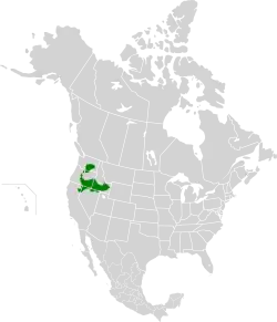
The Snake–Columbia shrub steppe is an ecoregion defined by the World Wide Fund for Nature (WWF). This ecoregion receives little precipitation because it is within the rain shadow of the Cascade Range. It takes in a western portion of the Columbia Basin in Washington, and extends south along the Deschutes River Basin, expanding to cover most of southeast Oregon. This ecoregion reaches south from Oregon into northern Nevada and the northeast corner of California. It also connects east onto the Snake River Plain, which it follows east from Hells Canyon to the continental divide in eastern Idaho.[2]
| Snake–Columbia shrub steppe | |
|---|---|
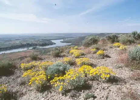 Shrub-steppe of Hagerman Fossil Beds National Monument, Idaho | |
 | |
| Ecology | |
| Realm | Nearctic |
| Biome | Deserts and xeric shrublands |
| Borders | |
| Bird species | 207[1] |
| Mammal species | 104[1] |
| Geography | |
| Area | 218,077[2] km2 (84,200 sq mi) |
| Country | United States |
| States | Washington, Oregon, California, Idaho and Nevada |
| Conservation | |
| Habitat loss | 19.112%[1] |
| Protected | 58.45%[1] |
Information about this ecoregion is covered by two articles that follow the ecoregion definitions of the United States Environmental Protection Agency:
References
- "Atlas of Global Conservation". The Nature Conservancy. Retrieved 2017-05-08.
- "Snake-Columbia shrub steppe". World Wide Fund for Nature. Retrieved 2019-01-01.