South Carolina Highway 198
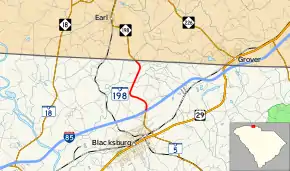
South Carolina Highway 198 (SC 198) is a 2.660-mile (4.281 km) primary state highway in the U.S. state of South Carolina. It connects the town of Blacksburg at Interstate 85 (I-85) exit 102 and the northern terminus of SC 5 with the town of Earl, North Carolina by way of North Carolina Highway 198 (NC 198). Though it physically travels north and south, internal SCDOT data and the only signage of SC 198 at the I-85/SC 5 interchange indicates that it travels east–west.[1][2]
| ||||
|---|---|---|---|---|
| Mountain Street | ||||
 | ||||
| Route information | ||||
| Maintained by SCDOT | ||||
| Length | 2.660 mi[1] (4.281 km) | |||
| Existed | 1940–present | |||
| Major junctions | ||||
| West end | ||||
| East end | ||||
| Location | ||||
| Counties | Cherokee | |||
| Highway system | ||||
| ||||

Route description
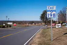
A two-lane rural highway, it traverses 2.66 miles (4.28 km), starting in Blacksburg, it goes north to the North Carolina state line at Buffalo Creek. The highway continues towards Earl and eventually to Patterson Springs.
History
Established in 1940, but designated later in 1951, SC 198 was 3.8-mile-long (6.1 km) and ran from U.S. Route 29/SC 5 to the North Carolina state line. Around 2006-2009, its southern terminus was shortened to I-85 and to a new western terminus of SC 5, which its southern section was designated too.[3]
Major intersections
The entire route is in Cherokee County.
| Location | mi[1] | km | Destinations | Notes | |
|---|---|---|---|---|---|
| Blacksburg | 0.000 | 0.000 | Western terminus of SC 198; northern terminus of SC 5; I-85 exit 102 | ||
| | 2.660 | 4.281 | Continuation into North Carolina | ||
| 1.000 mi = 1.609 km; 1.000 km = 0.621 mi | |||||
See also
 U.S. roads portal
References
- "Highway Logmile Report". South Carolina Department of Transportation. Retrieved December 26, 2020.
- Google (January 22, 2013). "StreetView image of I-85/SC 5/SC 198 interchange and overview map of SC 198" (Map). Google Maps. Google. Retrieved January 22, 2013.
- "Mapmikey's South Carolina Highways Page: SC 198". Retrieved January 8, 2012.
External links
 Media related to South Carolina Highway 198 at Wikimedia Commons
- SC 198 at Virginia Highways' South Carolina Highways Annex