South Carolina Highway 340
South Carolina Highway 340 (SC 340) is a 10.990-mile-long (17.687 km) state highway in the U.S. state of South Carolina. The highway connects the Timmonsville area with Darlington.
| ||||
|---|---|---|---|---|
| ||||
| Route information | ||||
| Maintained by SCDOT | ||||
| Length | 10.990 mi[1] (17.687 km) | |||
| Major junctions | ||||
| South end | ||||
| ||||
| North end | ||||
| Location | ||||
| Counties | Darlington | |||
| Highway system | ||||
| ||||

Route description
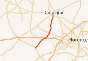
SC 340 begins at an intersection with SC 403 (Oates Highway) north-northwest of Timmonsville, within Darlington County. It travels to the northeast and crosses Middle Swamp and Myrtle Branch before an interchange with Interchange 20 (I-20). It crosses over Jeffries Creek and High Hill Creek before entering the city limits of Darlington. There, it intersects U.S. Route 52 (US 52; Governor Williams Highway). It crosses some railroad tracks before it meets its northern terminus, an intersection with SC 34 (Pearl Street).[2]
Major intersections
The entire route is in Darlington County.
| Location | mi[1] | km | Destinations | Notes | |
|---|---|---|---|---|---|
| | 0.000 | 0.000 | Southern terminus | ||
| | 3.940 | 6.341 | I-20 exit 137 | ||
| Darlington | 10.240 | 16.480 | |||
| 10.990 | 17.687 | Northern terminus | |||
| 1.000 mi = 1.609 km; 1.000 km = 0.621 mi | |||||
See also
 U.S. roads portal
 United States portal
References
- "Highway Logmile Report". South Carolina Department of Transportation. Retrieved November 22, 2020.
- Google (May 14, 2016). "South Carolina Highway 340" (Map). Google Maps. Google. Retrieved May 14, 2016.
External links
 Media related to South Carolina Highway 340 at Wikimedia Commons
- SC 340 South Carolina Hwy Index
This article is issued from Wikipedia. The text is licensed under Creative Commons - Attribution - Sharealike. Additional terms may apply for the media files.