South Carolina Highway 53
South Carolina Highway 53 (SC 53) is a 11.900-mile-long (19.151 km) state highway in the U.S. state of South Carolina. The highway connects Shiloh with rural areas of Sumter County.
| ||||
|---|---|---|---|---|
 | ||||
| Route information | ||||
| Maintained by SCDOT | ||||
| Length | 11.900 mi[1] (19.151 km) | |||
| Major junctions | ||||
| South end | ||||
| North end | ||||
| Location | ||||
| Counties | Sumter | |||
| Highway system | ||||
| ||||

Route description
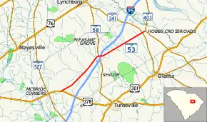
SC 53 begins at an intersection with US 378 (Myrtle Beach Highway) southwest of Shiloh, within Sumter County. It travels to the northeast, through rural areas of the county, and curves to a nearly due east direction. It intersects SC 58 (Pleasant Grove Road), and the two highways begin a concurrency. They have an interchange with Interstate 95 (I-95), where they enter Shiloh. Approximately 500 feet (150 m) later, SC 53 splits off to the south, onto Pudding Swamp Road. SC 53 continues through rural areas of the county to an intersection with SC 341 (Mt. Zion Road). About 2,000 feet (610 m) later is the highway's northern terminus, an intersection with SC 403 (Lynches River Road/Amwell Church Road). This is southwest of the Lynches River.[2]
Major intersections
The entire route is in Sumter County.
| Location | mi[1] | km | Destinations | Notes | |
|---|---|---|---|---|---|
| | 0.000 | 0.000 | Southern terminus | ||
| | 5.950 | 9.576 | Southern end of SC 58 concurrency | ||
| Shiloh | 6.145– 6.200 | 9.889– 9.978 | I-95 exit 141 | ||
| 6.380 | 10.268 | Northern end of SC 58 concurrency | |||
| | 11.510 | 18.524 | |||
| | 11.900 | 19.151 | Northern terminus | ||
1.000 mi = 1.609 km; 1.000 km = 0.621 mi
| |||||
Hobbs Crossroads alternate route
| |
|---|---|
| Location | Hobbs Crossroads |
| Existed | 1938–1947 |
South Carolina Highway 53 Alternate (SC 53 Alt.) was an alternate route that existed partially in Hobbs Crossroads. In May 1938, it was established from SC 341 south-southwest of the community, north-northeast to SC 53 and SC 309 in the community, then west-northwest and northwest back to SC 341. In 1947, it was decommissioned. Today, it is known as Amwell Church Road and Lynches River Road.
The entire route was in Sumter County.
| Location | mi | km | Destinations | Notes | |
|---|---|---|---|---|---|
| | Southern terminus | ||||
| Hobbs Crossroads | Northern terminus of SC 309, which is now SC 403 | ||||
| | Northern terminus | ||||
| 1.000 mi = 1.609 km; 1.000 km = 0.621 mi | |||||
See also
 U.S. roads portal
 United States portal
References
- "Highway Logmile Report". South Carolina Department of Transportation. Retrieved December 23, 2020.
- Google (May 6, 2016). "South Carolina Highway 53" (Map). Google Maps. Google. Retrieved May 6, 2016.
External links
 Media related to South Carolina Highway 53 at Wikimedia Commons
- SC 53 at Virginia Highways' South Carolina Highways Annex
- Former SC 53 ALT at Virginia Highways' South Carolina Highways Annex