South Carolina Highway 541
South Carolina Highway 541 (SC 541) is a 10.660-mile (17.156 km) state highway in the U.S. state of South Carolina. The highway connects Olanta with Coward.
| ||||
|---|---|---|---|---|
| ||||
| Route information | ||||
| Maintained by SCDOT | ||||
| Length | 10.660 mi[1] (17.156 km) | |||
| Major junctions | ||||
| West end | ||||
| East end | ||||
| Location | ||||
| Counties | Florence | |||
| Highway system | ||||
| ||||

Route description
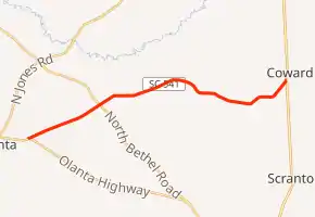
SC 541 begins at an intersection with SC 341 (East Hampton Street/Olanta Highway) just east of Olanta, within Florence County. It travels to the east-northeast and crosses over Camp Branch before intersecting SC 403 (North Bethel Road). The highway curves to the east-southeast. When it enters Coward, it curves to the northeast and meets its eastern terminus, an intersection with U.S. Route 52 (US 52).[2]
Major intersections
The entire route is in Florence County.
| Location | mi[1] | km | Destinations | Notes | |
|---|---|---|---|---|---|
| | 0.000 | 0.000 | Western terminus | ||
| | 2.950 | 4.748 | |||
| Coward | 10.660 | 17.156 | |||
| 1.000 mi = 1.609 km; 1.000 km = 0.621 mi | |||||
See also
 U.S. roads portal
 United States portal
References
- "Highway Logmile Report". South Carolina Department of Transportation. Retrieved December 28, 2020.
- Google (May 16, 2016). "South Carolina Highway 541" (Map). Google Maps. Google. Retrieved May 16, 2016.
External links
 Media related to South Carolina Highway 541 at Wikimedia Commons
- SC 541 at Virginia Highways' South Carolina Highways Annex
This article is issued from Wikipedia. The text is licensed under Creative Commons - Attribution - Sharealike. Additional terms may apply for the media files.