Southern Orchards
Southern Orchards is an established neighborhood on the near south side of Columbus, Ohio. It is located immediately southeast of downtown and is the 23rd most walkable neighborhood in Columbus with 3,538 residents.[1] The neighborhood is the target of revitalization and beautification largely due to its anchor institution Nationwide Children's Hospital[2] and a renewed interest in urban living in the city's core. Since 2008, more than 90 properties have been improved through the hospital’s Healthy Homes program and continued revitalization is occurring along the major streets of Livingston and Parsons Avenues as the city moves to reconnect downtown to its surrounding neighborhoods.[3]
Southern Orchards | |
|---|---|
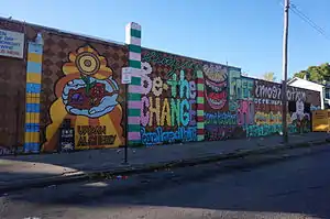 Wall Art | |
| Coordinates: 39°56′47″N 82°58′25″W | |
| ZIP Code | 43206 |
| Area code(s) | 614 |
History
The first development in the Near Southside Area was the city’s land purchase of what is now Livingston Park in front of Nationwide Children’s Hospital in 1839. Initially used as a graveyard, the graves were relocated and the land was developed into Livingston Park in 1885.[4] What is now Nationwide Children’s Hospital was founded in 1892.[5] By the mid-1870s, land south of Livingston was subdivided into streets and lots. One of the early subdivisions to develop was Swayne's Addition at the corner of Parsons and Livingston Avenues. Wager Swayne served in the American Civil War and rose to the rank of Major General. Beck Street was originally called Swayne Street before it was changed; however, Wager Street still remains.[6] The new subdivision developed quickly, and within 20 years the neighborhood expanded further, with parcels east of 22nd Street given the name Olde Orchard in the county auditor's records. In time, the area became known as Southern Orchards, to differentiate itself from the Olde Orchard neighborhood being developed at the time southeast of what is now John Glenn Columbus International Airport.[7]
Geography
Boundaries
Southern Orchards is bounded by East Livingston Avenue to the north, East Whittier Street to the south, Linwood Avenue to the east, and Parsons Avenue to the west. The area includes 7 primary road corridors as identified through the 1993 Columbus Thoroughfare Plan –Livingston Avenue, Whittier Street, Parsons Avenue, Ohio Avenue, Champion Avenue, Lockbourne Road and Fairwood Avenue. Interstate 70 also follows the northern border of the planning area before it turns south between the Norfolk Southern Railway and Alum Creek.[8]
Land Use
The Livingston Avenue and Parsons Avenue corridors consist of predominantly commercial, office, and multifamily development. A majority of the neighborhood remains single-family residential units.
Residential
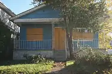
Home vacancy is a major problem within the area; in 2012, over 369 of the homes in the neighborhood were vacant, indicating over a 20% vacancy rate. Much work has gone into revitalizing the area and building new homes due to the efforts of the mayor and his team, Nationwide Children's Hospital, and several other donors.[9] In 2012, the Urban Infrastructure Recovery Fund Program included the Southern Orchards Civic Association for the Proposed Project List. Total funding of $270,000 was used to improve Martin Park with walkways, benches, trees, fencing and playground equipment and to construct curb ramps on Whittier Street between Wilson Avenue and Wager Street. Multifamily zoning is located along Whittier Street and Livingston Avenue.
Commercial
Parsons Avenue and portions of Livingston Avenue have the Urban Commercial Overlay (UCO) zoning designation. The UCO does not address land use; it focuses on protecting the unique architectural and aesthetic characteristics of older urban commercial corridors and encourages pedestrian-oriented development featuring retail display windows, reduced building setbacks, rear parking lots, and other pedestrian-oriented site design elements.[10] Parsons Avenue is in the Neighborhood Commercial Revitalization (NCR) district. The program’s goal is to stimulate business development along designated NCR areas. The NCR program offers technical assistance, loans and matching grants, capital improvements and planning services in conjunction with the established business association in six commercial areas surrounding downtown.[11] CVS Pharmacy, Aetna Building Maintenance, E-Jay's Drive Thru, Revol Wireless, Mezmerize, Crazy Chicken, Papa John’s, and Nexcel/FoodMart are some businesses located in the neighborhood.[12] Grocery stores in the Southern Orchards include Little's IGA (supermarkets).[13] In 1999, the Free Store on Parsons Avenue opened, which accepts donations and distributes clothes and household items to the area’s poor. By the end of this year, 150,000 people will have walked through its doors since it opened.[14] Community Development for All People is affiliated with the United Methodist Church and was incorporated as a nonprofit community-development corporation in 2003. The city then designated it as the community housing-development organization for the area so it could receive federal funding.[15]
Revitalization
From Parsons to Linwood the Southern Orchard neighborhood has plenty of blocks with brick homes vs. wood-frame houses.[16] Neighbors are trying to clean up the Southern Orchards neighborhood and think broken down cars with flat tires, some sitting on cinder blocks only add to the blight.[17] The neighborhood group is the Southern Orchards Civic Association, led by President Elizabeth Norris and Vice-President Ashley Fuentes. Meetings are held the first Tuesday of the month at 6 p.m at Stowe Mission, 888 Parson Avenue. Atticus Garden represents Southern Orchards (District 2) on the Columbus South Side Area Commission.[18]
Southern Gateway Initiative
The Southern Gateway Initiative began as a private investment by local neighborhood champions to revitalize the near south side area with new housing, health and wellness facilities, and upgraded neighborhood infrastructure. Over $5.7 million in private dollars was raised towards the initiative and the City of Columbus invested $18 million more dollars to rehabilitate homes and upgrade even more infrastructure.[19]
Southside Home Ownership Program
The Southside Home Ownership Program oversaw the renovation of 14 houses in the Southern Orchards area. The renovated homes were vacant and sold as owned homes. Eligible buyers had an income below 80% of the median area income. Grants were used to subsidize the homes and provide down payment assistance.[20]
Healthy Homes
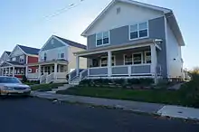
Church and Community Development for all People (CD4AP) teamed up with Nationwide Children’s Hospital in 2008 to form the Healthy Neighborhoods, Healthy Families (HNHF) Realty Collaborative, with the intent to rehabilitate, repair, and build homes within a 38 block area to the immediate south and east of the hospital’s main campus. The goal of Healthy Homes is to continue making improvements on homes throughout the community over a 5-year period.[21] Since 2008, Healthy Homes has renovated 90 houses and built 23 new ones in the neighborhood and 159 homes have received new roofs or siding.[22]
Livingston Avenue Area Commission (LAVA-C)
Boundaries:
- North: I-70
- East: Alum Creek
- South: E. Livingston/ E. Whittier Street
- West: Lehman St./Kennedy Dr.[23]
Commission Meetings take place on the third Tuesday of each month at 6:30 pm at the St. John's Learning Center located at 640 S. Ohio Ave.[24]
Structures & Landmarks
Livingston Park
Livingston Park, located north of Southern Orchards, is the oldest piece of park property in the City of Columbus and is listed on the list of Nationally Registered Historic Landmarks.[14] Plant Pride on Parsons', beautification efforts began in 2010.[15] Plant Pride on Parsons is an award-winning community greening partnership developed to assist revitalization of the historic Parsons commercial corridor by abating litter and graffiti and creating a botanical gallery of hand-painted flowering containers and nature-scape murals.[16]
Children's Hospital Campus
_-_exterior.JPG.webp)
Nationwide Children’s Hospital is the fourth largest children's hospital in the country serving over 37 counties in Ohio. The hospital has more than 1,100 medical staff members and 9,200 employees with the continued mission of providing medical care to children regardless of their ability to pay. Nationwide Children's completed an $800 million expansion project, which includes a new $480 million main hospital and a performance space for patient activities. The new hospital, which opened in 2012, has all private rooms and a new emergency department. Surrounding neighborhood investment by the hospital includes: 3 to $5 million to buy and renovate up to 50 houses in the area, the establishment of significant green spaces on the hospital campus, and Nationwide Children’s Hospital's Research 3 building.[25]
Ronald McDonald House
The Ronald McDonald House of Central Ohio (RMHC), located in the Southern Orchards, has been serving families of sick children for more than 30 years, providing housing, food, and peace of mind to its visitors. The current building is the second location for the house which is now located on the south side of Livingston Avenue facing Children's Hospital. The current location opened in 2008 with 80 bedrooms and has since expanded by 57 more rooms in 2014 and is one of the largest Ronald McDonald Houses in the nation.[26]
Livingston Avenue Elementary School
Livingston Avenue Elementary School is located in the area [27] serving Kindergarten through 5th grade. In 2012, because of declining enrollment, nearby Heyl Elementary School was closed.[28] [29]
Faith centers
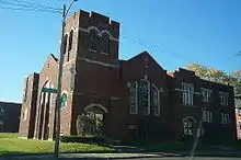
The Family Missionary Baptist Church and Guiding Light Christian Center are central community centers. They provide faith, recreation, and youth services.
Theodore Roosevelt Junior High School
Construction of Theodore Roosevelt Junior High School began in 1913 and it was demolished February 11, 1987. The building was a public school that sat at 1046 Struder Ave and served the Near South and Driving Park neighborhoods.[30]
Kossuth Street Garden
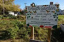
Kossuth Street Garden covers the entire lot 641 E. Kossuth Street, located in the Southern Orchards neighborhood just east of German Village. Founder and director Michael Doody has been serving the community since 2007.[31]
Parks and recreation
Kobacker Park, located at 570 Kossuth Street, is a .34 acre neighborhood, open-lot park. .[32]
Roosevelt Park, located at 1046 Studer Ave., is a 2.91 acre neighborhood park that includes picnic tables, looping walking path and play equipment for children.[33]
Martin Park, located at 950 Wagner St., is a mowed open lot park.[34]
Columbus Library Branches
Columbus Metropolitan Library branches near the area include the Driving Park Branch, which is located in the northeastern portion of the planning area at Kelton and Livington Avenues, and the Parsons Avenue Branch, located just southwest of the planning area at the corner of Stewart and Parsons Avenues.[35]
Transportation
To help address the gaps in the sidewalk infrastructure, the city of Columbus plans to construct sidewalks on Whittier Street, between Lockbourne Road and Fairwood Avenue.[36] The recently adopted Columbus Bicentennial Bike Plan suggests several routes to be constructed in the Near Southside Area including Cycling infrastructure.[37] Bike boulevards are recommended for Denton Alley, and East Gates and Kossuth Streets. It recommends bike lanes for Lockbourne Road, and Parsons, Champion, Ohio, and Livingston Avenues.[38] Central Ohio Transportation Authority (COTA) bus service provides a network of coverage in the Near Southside Planning Area. Local routes serve Livingston Avenue, Parsons Avenue, and Whittier Street Line numbers 001, 004, 005. Crosstown routes serve both Ohio and Champion Avenues; Line number 022[39] The COTA routes connect residents to downtown and to the broader region.
Notes
- Score, Walk. "Living in Southern Orchards Columbus". www.walkscore.com/. Walk Score. Retrieved 29 November 2014.
- Ross, John. "Groups investing in South Side Neighborhood". www.columbusalive.com/. Columbus Alive. Retrieved 13 November 2014.
- Ross, John. "Groups investing in South Side neighborhood". www.columbusalive.com/. Columbus Alive. Retrieved 29 November 2014.
- Division, Planning. "Near Southside Area Plan 2011" (PDF). columbus.gov/. City of Columbus. Retrieved 29 November 2014.
- Children's Hospital, Nationwide. "Our History". www.nationwidechildrens.org/. Nationwide Children's Hospital. Retrieved 29 November 2014.
- Division, Planning. "Near Southside Area Plan 2011" (PDF). columbus.gov/. City of Columbus. Retrieved 29 November 2014.
- Darbee, Jeff. "New Life for and Old Abbey". www.columbusmonthly.com/publisher=Columbus Monthly. Retrieved 5 May 2020.
- Division, Planning. "Near Southside Area Plan 2011" (PDF). columbus.gov/. City of Columbus. Retrieved 29 November 2014.
- Retrieved November 12, 2014
- Division, Planning. "Near Southside Area Plan 2011" (PDF). columbus.gov/. City of Columbus. Retrieved 29 November 2014.
- Division, Planning. "Near Southside Area Plan 2011" (PDF). columbus.gov/. City of Columbus. Retrieved 29 November 2014.
- Design Center, Neighborhood. "NEIGHBORHOOD COMMERCIAL REVITALIZATION (NCR) PARSONS AVENUE - COMMERCIAL INVENTORY" (PDF). parsonsavenuencroptionb.weebly.com/. City of Columbus. Retrieved 29 November 2014.
- Area Vision Plan. "Greater Parsons Avenue - Asset Library" (PDF). assets.columbus.gov/. City of Columbus. Retrieved 13 November 2014.
- "Nonprofit's leader key to South Side housing". www.dispatch.com/. Columbus Dispatch. Retrieved 29 November 2014.
- "Nonprofit's leader key to South Side housing". www.dispatch.com/. Columbus Dispatch. Retrieved 29 November 2014.
- Fisher, Ann. "Historic Urban Neighborhood". wosu.org/. WOSU. Retrieved 29 November 2014.
- Hove, Harrison. "Neighbors Fed Up With Broken Down Cars In South Columbus Neighborhood". www.nbc26.tv/. NBC4. Retrieved 29 November 2014.
- "What comes next after abandoned houses are demolished?". www.dispatch.com/. Columbus Dispatch. Retrieved 29 November 2014.
- Columbus Underground Retrieved November 12, 2014
- SouthSide Home Ownership Program Retrieved November 12, 2014
- Healthy Neighborhoods Retrieved November 12, 2014
- Weiker, Jim. "House buyers find Southern Orchards neighborhood, east of Parsons, ripe for revival". The Columbus Dispatch. Retrieved 2018-05-14.
- Development, Department of. "Livingston Avenue Area Commission". columbus.gov/. City of Columbus. Retrieved 16 December 2014.
- Development, Department of. "Livingston Avenue Area Commission". columbus.gov/. City of Columbus. Retrieved 16 December 2014.
- Division, Planning. "Near South Side Plan" (PDF). columbus.gov. City of Columbus. Retrieved 9 December 2014.
- Ronald McDonald House Retrieved November 12, 2014
- "Livingston Elementary School". livingstones.ccsoh.us/. Columbus City Schools. Retrieved 13 November 2014.
- Richards, Jennifer Smith. "Closing of Columbus schools has upside". www.dispatch.com/. Columbus Dispatch. Retrieved 13 November 2014.
- Livingston Ave Elementary School Retrieved November 12, 2014
- Theodore Roosevelt Junior High School Retrieved November 12, 2014
- "Community garden volunteers sought for April 19". www.thisweeknews.com/. This Week News. Retrieved 29 November 2014.
- and Parks, Recreation. "Kobacker Park". columbus.gov/. City of Columbus. Retrieved 29 November 2014.
- and Parks, Recreation. "Roosevelt Park". www.columbus.gov/. City of Columbus. Retrieved 29 November 2014.
- and Parks, Recreation. "Martin Park". www.columbus.gov/. City of Columbus. Retrieved 29 November 2014.
- Division, Planning. "Near Southside Area Plan 2011" (PDF). columbus.gov/. City of Columbus. Retrieved 29 November 2014.
- Division, Planning. "Near Southside Area Plan 2011" (PDF). columbus.gov/. City of Columbus. Retrieved 29 November 2014.
- Division, Planning. "Near Southside Area Plan 2011" (PDF). columbus.gov/. City of Columbus. Retrieved 29 November 2014.
- Division, Planning. "Near Southside Area Plan 2011" (PDF). columbus.gov/. City of Columbus. Retrieved 29 November 2014.
- "Central Ohio Transit Authority" (PDF). www.cota.com/. Central Ohio Transit Authority. Retrieved 13 November 2014.