Stillaguamish River
The Stillaguamish River is a river in northwest Washington in the United States. It is mainly composed of two forks, the longer North Fork Stillaguamish (45 miles (72 km)) and the South Fork Stillaguamish. The two forks join near Arlington. From there the Stillaguamish River proper flows for 22 miles (35 km) to Puget Sound. The river's watershed drains part of the Cascade Range north of Seattle.
| Stillaguamish River | |
|---|---|
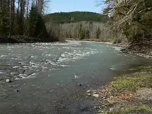 The South Fork of the Stillaguamish River near Verlot | |
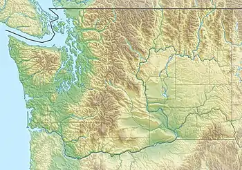 Location of the mouth of the Stillaguamish River in Washington  Stillaguamish River (the United States) | |
| Location | |
| Country | United States |
| State | Washington |
| Physical characteristics | |
| Source | North Cascades |
| • coordinates | 48°12′14″N 122°7′38″W[1] |
| Mouth | Puget Sound |
• location | Port Susan |
• coordinates | 48°14′18″N 122°22′38″W[1] |
• elevation | 0 m (0 ft) |
| Length | 67 mi (108 km)[2] |
| Basin size | 700 sq mi (1,800 km2) |
Course

The Stillaguamish River is formed from the confluence of the North and South Forks, both of which rise in the Cascades. The North Fork rises as several branches in a remote area of Skagit County near Finney Peak, approximately 10 miles (16 km) north of Darrington. Collecting many tributary creeks, the river flows south, then west through the foothills along the Skagit-Snohomish county line. Tributaries of the North Fork Stillaguamish River include Boulder River and Deer Creek.
The South Fork (30 miles (48 km)) originates from the northern slopes of Del Campo Peak and Morning Star Peak in central Snohomish County, 20 miles (32 km) south of Darrington, and flows west and northwest by Silverton, Verlot, and Granite Falls.
The two forks unite at Arlington in northwestern Snohomish County. The combined stream flows west, entering the north end of Port Susan, an arm of Puget Sound, in Stanwood, approximately 10 miles (16 km) west of Arlington. Between the North and South Forks there is a portion of the Mount Baker-Snoqualmie National Forest called the Boulder River Wilderness.
Natural history
The Stillaguamish River and its tributaries are known for their salmon runs. Eight salmonid species use the streams for spawning, including Chinook, coho, chum, pink, and sockeye salmon, steelhead trout, sea-run cutthroat, and bull trout.
Hydrology
The north fork of the Stillaguamish river level is monitored by gauges operated by the United States Geological Survey (USGS),[3] and river levels can vary by as much as 13 feet (4.0 m). The river level rises and falls very quickly, with the average north fork flood duration of eight hours. Of the five highest north fork flood levels on record, three have occurred since 2009.[4]
History
Variant names for the Stillaguamish River, according to the USGS, include Tuxpam River, Stoh-luk-whahmpsh River, Stillaquamish River, Steilaguamish River, Stalukahamish River, and other similar spellings.
The 2014 Oso landslide occurred on the North Fork of the Stillaguamish.
See also
References
- U.S. Geological Survey Geographic Names Information System: Stillaguamish River
- Including North Fork
- "National Weather Service Advanced Hydrologic Prediction Service". water.weather.gov. Retrieved Jun 21, 2020.
- "Historical Crests for North Fork Stillaguamish River near Arlington". water.weather.gov. Retrieved Jun 21, 2020.