Sundal
Sundal or Sunndal is the largest village in the Mauranger district of Kvinnherad municipality in Vestland county, Norway. The village is located on the southern shore of the Maurangsfjorden, south of Nordrepollen and Gjetingsdalen. The village of Austrepollen lies to the east of Sunndal. It sits in a deep valley, with steep mountains surrounding it on three sides. The Bondhusbreen glacier is located at the southern end of the valley.[2]
Sunndal
Sundal | |
|---|---|
Village | |
 Sunndal Location of the village  Sunndal Sunndal (Norway) | |
| Coordinates: 60°07′02″N 06°16′04″E | |
| Country | Norway |
| Region | Western Norway |
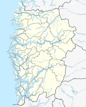
| County | Vestland |
| District | Sunnhordland |
| Municipality | Kvinnherad |
| Elevation | 7 m (23 ft) |
| Time zone | UTC+01:00 (CET) |
| • Summer (DST) | UTC+02:00 (CEST) |
| Post Code | 5476 Mauranger |
The village has been a centre of tourism for over 150 years. There are about 70 inhabitants in the village, which has a camping ground, a shop, and an inn. At the end of the 19th century, German and English tourists travelled to Sundal to experience the great nature including the nearby Folgefonna glacier, and the small Bondhusbreen arm which reaches into the valley towards Sundal. Today, the nearby Folgefonna National Park is a major draw to the area which is popular among outdoor enthusiasts.
Media gallery
 View of the village
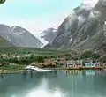 Sundal, circa 1910
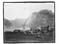 Sundal harbour, circa 1880-1910
References
- "Sunndal, Kvinnherad (Hordaland)" (in Norwegian). yr.no. Retrieved 24 March 2015.
- Store norske leksikon. "Bondhusbreen" (in Norwegian). Retrieved 24 March 2015.