Tūtaekurī River
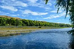
The Tūtaekurī River flows through the Hawke's Bay Region of the eastern North Island of New Zealand. It flows east from the Kaweka Range, reaching the Pacific Ocean just to the south of Napier and Taradale, where the Ngaruroro and Clive Rivers join it.[1] Starting roughly 50 kilometers north east of Taihape, the Tūtaekurī River flows for a distance of 99.9 kilometers.
| Tūtaekurī River | |
|---|---|
 | |
| Location | |
| Country | New Zealand |
| Physical characteristics | |
| Source | |
| • location | Kaweka Ranges |
| • elevation | 759 m (2,490 ft) |
| Mouth | |
• location | Heretaunga Plains |
• elevation | Sea Level |
| Length | 99.9 km (62.1 mi) |
Ngāti Paarau, which is the local hapū (sub-tribe) are said to have disposed of their waste food in this river. Tribes such as Ngāti Pahauwera travelled to this river to share food and trade.
The literal English translation of the Māori name can be broken down into tūtae meaning faeces,[2] and kurī meaning dog.[3]
Redirection
Up until 1931, the lowest part of the Tūtaekurī River flowed north, following its original channel (the location of present-day Taradale) and into Ahuriri Harbour. In the 1931 Hawke's Bay earthquake, the land underneath Ahuriri Harbour was drastically raised. The river was forced to seek an alternative route and started to back up, and so the residents of Hawke's Bay dug out a new, alternate path connecting it to the Ngaruroro River, into which it still flows today.[4]
References
- "Place name detail: Tūtaekurī River". New Zealand Gazetteer. New Zealand Geographic Board. Retrieved 18 April 2020.
- maoridictionary.co.nz https://maoridictionary.co.nz/word/8800. Retrieved 15 June 2019. Missing or empty
|title=(help) - maoridictionary.co.nz https://maoridictionary.co.nz/word/3309. Retrieved 15 June 2019. Missing or empty
|title=(help) - http://www.teara.govt.nz/en/1966/tutaekuri-river