Takamori, Kumamoto
Takamori (高森町, Takamori-machi) is a town located in Aso District, Kumamoto Prefecture, Japan.
Takamori
高森町 | |||||||||||
|---|---|---|---|---|---|---|---|---|---|---|---|
Town | |||||||||||
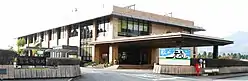 Takamori town hall | |||||||||||
 Flag  Seal | |||||||||||
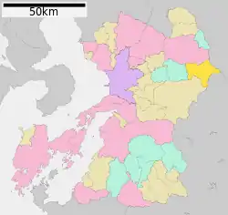 Location of Takamori in Kumamoto Prefecture | |||||||||||
 Takamori Location in Japan | |||||||||||
| Coordinates: 32°49′N 131°7′E | |||||||||||
| Country | Japan | ||||||||||
| Region | Kyushu | ||||||||||
| Prefecture | Kumamoto Prefecture | ||||||||||
| District | Aso | ||||||||||
| Area | |||||||||||
| • Total | 174.90 km2 (67.53 sq mi) | ||||||||||
| Population (October 1, 2016) | |||||||||||
| • Total | 6,189 | ||||||||||
| • Density | 35/km2 (92/sq mi) | ||||||||||
| Time zone | UTC+09:00 (JST) | ||||||||||
| City hall address | Takamori-machi, 2168 Ōji-Takamori 869-1602 | ||||||||||
| Website | www | ||||||||||
| |||||||||||
As of October 1, 2016, the town has an estimated population of 6,189 and a density of 35 persons per km². The total area is 174.90 km².
Geography
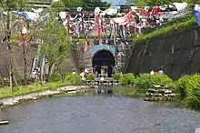
Takamori Spring Tunnel Park in May
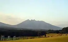
Mt. Nekodake
Located at the easternmost point of Kumamoto Prefecture, it is located in the caldera of Mount Aso. It touches Ōita prefecture to the northeast and Miyazaki prefecture to the east. The town is divided into four areas, called Takamori, Shikimi, Kusakabe, and Nojiri. The city hall is situated in the Takamori area, where over half of the town population resides.
- Mountains: Mount Aso, Nakadake, Nekodake, Takadake, Kishimadake, Eboshidake
- Rivers: Shirakawa
Surrounding municipalities
Education
- High Schools
- Takamori High School
- Junior High Schools
- Takamori Higashi Junior High School
- Takamori Junior High School
- Primary Schools
- Takamori Higashi Elementary School
- Takamori Chūō Elementary School
External links
 Media related to Takamori, Kumamoto at Wikimedia Commons
- Takamori official website (in Japanese)
| Authority control |
|---|
This article is issued from Wikipedia. The text is licensed under Creative Commons - Attribution - Sharealike. Additional terms may apply for the media files.