Tanafjord
The Tanafjord or Tanafjorden (Northern Sami: Deanuvuotna) is a large fjord in Troms og Finnmark county, Norway. It is located in the municipalities of Tana, Gamvik, and Berlevåg. Its orientation is mainly north-south, reaching approximately 65 kilometres (40 mi) from the small village of Smalfjord in Tana Municipality in the south to the mouth of the fjord at the Barents Sea. The fjord separates the Nordkinn Peninsula (Gamvik Municipality) in the west from the Varanger Peninsula (Berlevåg Municipality) in the east.[1]
| Tanafjorden | |
|---|---|
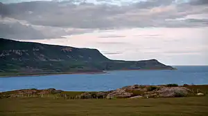 View of the fjord | |
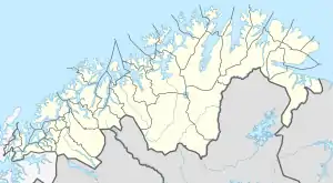 Tanafjorden Location of the fjord  Tanafjorden Tanafjorden (Norway) | |
| Location | Troms og Finnmark county, Norway |
| Coordinates | 70.7800°N 28.4508°E |
| Type | Fjord |
| Native name | Deanuvuotna |
| Primary inflows | Tana River |
| Primary outflows | Barents Sea |
| Basin countries | Norway |
| Max. length | 65 kilometres (40 mi) |
| Max. width | 8 to 12 km (5.0 to 7.5 mi) |
The Tana River empties into the southern part of the fjord. There are several side fjords which branch off of the main Tanafjorden including the Hopsfjorden, Langfjorden, and Gulgofjorden. There are some settlements along the fjord, but they are all small and rather isolated. Settlements include the villages of Vestertana, Austertana, Trollfjorden, Skjånes, Nervei, and Store Molvik. Norwegian County Road 98 and Norwegian County Road 890 run along the southern parts of the fjord.[1]
See also
References
- Store norske leksikon. "Tanafjorden" (in Norwegian). Retrieved 2013-02-23.
| Authority control |
|
|---|