Tell Maon
Tell Maon (Arabic: Khirbet Ma'in) was a biblical town in the Hebron Hills, formerly known simply as Maon (Hebrew: מעון), rising 863 metres (2,831 ft) above sea level. The town, now a ruin, is mentioned in Joshua 15:55 and in 1 Samuel 25:2, and is located about 6 kilometres (3.7 mi) southeast of Yatta.
Tell Maon
خربة معين Arabic ח'רבת מעין Hebrew | |
|---|---|
Ruin | |
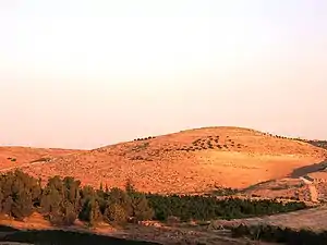 Tell Ma'on near Hebron | |
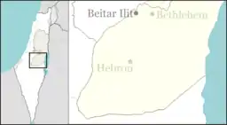 Tell Maon Location of Tell Maon | |
| Coordinates: 31°24′34″N 35°08′02″E | |
| Region | West Bank |
| District | Judea and Samaria Area |
| Government | |
| • Council | Har Hevron (Mount Hebron) Regional Council |
| Time zone | UTC+2 (IST) |
| • Summer (DST) | UTC+3 (IDT) |
History
The site is first mentioned as one of the cities of Judah.[1][2] Maon was the place of birth of Nabal the Carmelite. In 1 Samuel 23:24–25, "the wilderness of Maon" is mentioned as a place of refuge for David when he fled from king Saul.[1] The site is not referred to again in biblical sources, and only after the destruction of the Second Temple is there a reference to the site again, where Rabban Yohanan ben Zakkai is said to have gone up to Maon of Judah.[1][3]
In the early 4th-century CE, Maon was mentioned in Eusebius' Onomasticon as being "in the tribe of Judah; in the east of Daroma."[4] The name "Darom" (Arabic: ad-Darum) literally means "south," but in relation to the rest of Palestine it had the general connotation of the immediate territory in and around Beit Jibrin (Eleutheropolis), as evinced by Al-Muqaddasi.[5]
Archaeology
A synagogue dating back to the Talmudic period was discovered at Tell Maon.[6] Archaeologists have also discovered at the site potsherds dating back to the early Bronze Age, as well as from the Israelite period (where jar handles were found bearing the paleo-Hebrew inscription LMLK (= "for the king") and from the Hellenistic period.[1] Shards have also been found in situ from the Roman and Byzantine periods, and from the Middle Ages.[1]
C.R. Conder of the Palestine Exploration Fund visited the site in 1874,[7] during which time a brief description was written of the site:
Tell Maʻîn –– A mound some 100 feet high. On the west are foundations, caves, and cisterns, and foundations of a tower about 20 feet square. The masonry in this tower is large, with a broad irregular draft and a rustic boss. One stone was 3 feet 8 inches long, 2 feet 9 inches high, the draft about 3 inches wide. There is also a round well-mouth, 5 feet diameter, cut out of a single stone.[8]
Modern era
Today, on the northern slope of the Tell are settled several families who have recently moved there from Yatta.
See also
Further reading
- Ilan, Z. (1988). "Maon - A Synagogue from the period of the Talmud (מעון - בית כנסת מתקופת התלמוד)". Sela'it - A Monthly Magazine for the Youth (in Hebrew). Tel-Aviv: The Society for the Protection of Nature. 17 (2): 16–17. ISSN 0334-4479.
- Ilan, Z. (1991). Ancient Synagogues in Erez Israel (בתי כנסת קדומים בארץ ישראל). Tel-Aviv: Miśrad ha-biṭaḥon. ISBN 9650505229. OCLC 26159213.
- Amit, David (2003). Synagogues at Tell Maon and at Tell 'Anim, and the Jewish settlement in the south of Mount Hebron (בתי הכנסת בחורבת מעון ובחורבת ענים והיישוב היהודי בדרום הר חברון). Jerusalem: Hebrew University (Doctoral dissertation). OCLC 170885342.
Gallery
 Tell Maon in Hebron Hills
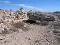 Tell Maon
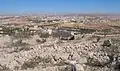
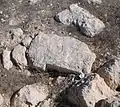 Ruin of Maon (near Hebron)
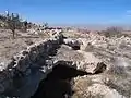 Remains of ancient wall at Tell Maon
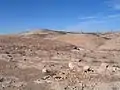 The ancient hill of Tell Maon
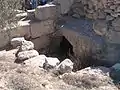 Old structures at Tell Maon
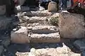 Staicase at Maon
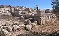 General ruins
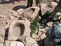 Stone troughs at the well of Maon
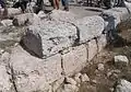 Remnants of Byzantine fort at Tell Maon
References
- Amit (n.d.), pp. 222–223
- Freedman (2000), p. 854
- Mekhilta of Rabbi Ishmael on Exodus 19:1
- Chapmann, et al. (2003), p. 72
- Al-Muqaddasi (1994), p. 157
- Amit (1997), p. 155
- Conder (1879), pp. 90–91
- Conder & Kitchener (1883), p. 415
Bibliography
- Al-Muqaddasi (1994). The Best Divisions for Knowledge of the Regions. Translated by Basil Anthony Collins. Reading: Garnet Publishing. ISBN 1-873938-14-4.
- Amit, David (n.d.). "Hurvat Ma'on". In Ben-Yosef, Sefi (ed.). Israel Guide - Judaea (A useful encyclopedia for the knowledge of the country) (in Hebrew). 9. Jerusalem: Keter Publishing House, in affiliation with the Israel Ministry of Defence. OCLC 745203905.
- Amit, David (1997), "A marble candelabrum from the synagogue of Maon in Judea", Judea and Samaria Research Studies (מחקרי יהודה ושומרון) (PDF) (in Hebrew), 7, Jerusalem: Israel Antiquities Authority, OCLC 741089250
- Chapmann III, R.L.; Taylor, J.E., eds. (2003). Palestine in the Fourth Century A.D.: The Onomasticon by Eusebius of Caesarea. Translated by G.S.P. Freeman-Grenville. Jerusalem: Carta. ISBN 965-220-500-1. OCLC 937002750.
- Conder, C.R. (1879). Tent Work in Palestine. A Record of Discovery and Adventure. 2. London: Richard Bentley & Son (published for the Committee of the PEF). OCLC 23589738.
- Conder, C.R.; Kitchener, H.H. (1883). The Survey of Western Palestine: Memoirs of the Topography, Orography, Hydrography, and Archaeology. 3. London: Committee of the Palestine Exploration Fund.
- Freedman, D.N.; Allen C. Myers (31 December 2000). Eerdmans Dictionary of the Bible. Amsterdam University Press. ISBN 978-90-5356-503-2.
External links
- Survey of Western Palestine, Map 25: IAA, Wikimedia commons (Tell Máîn shown on upper part of map)