Terrenate, Tlaxcala
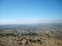
Terrenate (formally: San Nicolás Terrenate) is a city, and the surrounding municipality of the same name, in the Mexican state of Tlaxcala. It is situated in the highest part of the state, at 2,680 metres above sea level. "Terrenate" is a Nahuatl name meaning "land the colour of masa" (maize dough).
Location
Terrenate is in the extreme northeast of the state, adjacent to the municipalities of:
- to the west, Tetla de la Solidaridad, Emiliano Zapata, and Lázaro Cárdenas
- to the south, Huamantla and Xaloztoc
- to the east, Altzayanca
- to the north, Ixtacamaxtitlán in the neighbouring state of Puebla.
Economy
Chiefly agricultural: crops and livestock. Little other industry or employment opportunities. Migration levels, particularly to the United States, are high.
Climate
| Climate data for Terrenate (1951–2010) | |||||||||||||
|---|---|---|---|---|---|---|---|---|---|---|---|---|---|
| Month | Jan | Feb | Mar | Apr | May | Jun | Jul | Aug | Sep | Oct | Nov | Dec | Year |
| Record high °C (°F) | 29.0 (84.2) |
34.0 (93.2) |
35.0 (95.0) |
37.5 (99.5) |
33.0 (91.4) |
32.0 (89.6) |
27.0 (80.6) |
27.0 (80.6) |
30.0 (86.0) |
32.0 (89.6) |
30.0 (86.0) |
28.0 (82.4) |
37.5 (99.5) |
| Average high °C (°F) | 20.6 (69.1) |
21.7 (71.1) |
23.2 (73.8) |
24.0 (75.2) |
23.4 (74.1) |
21.6 (70.9) |
21.2 (70.2) |
21.3 (70.3) |
21.0 (69.8) |
21.5 (70.7) |
21.4 (70.5) |
21.0 (69.8) |
21.8 (71.2) |
| Daily mean °C (°F) | 12.2 (54.0) |
13.1 (55.6) |
14.4 (57.9) |
15.7 (60.3) |
15.7 (60.3) |
15.1 (59.2) |
14.4 (57.9) |
14.4 (57.9) |
14.3 (57.7) |
14.1 (57.4) |
13.4 (56.1) |
12.7 (54.9) |
14.1 (57.4) |
| Average low °C (°F) | 3.7 (38.7) |
4.5 (40.1) |
5.6 (42.1) |
7.4 (45.3) |
8.0 (46.4) |
8.5 (47.3) |
7.6 (45.7) |
7.5 (45.5) |
7.7 (45.9) |
6.6 (43.9) |
5.4 (41.7) |
4.4 (39.9) |
6.4 (43.5) |
| Record low °C (°F) | −5.5 (22.1) |
−4.0 (24.8) |
−5.5 (22.1) |
0.0 (32.0) |
1.0 (33.8) |
1.0 (33.8) |
1.0 (33.8) |
2.0 (35.6) |
0.0 (32.0) |
−3.5 (25.7) |
−3.0 (26.6) |
−4.0 (24.8) |
−5.5 (22.1) |
| Average precipitation mm (inches) | 7.7 (0.30) |
11.1 (0.44) |
21.2 (0.83) |
53.1 (2.09) |
88.1 (3.47) |
139.1 (5.48) |
89.7 (3.53) |
111.5 (4.39) |
100.0 (3.94) |
60.0 (2.36) |
15.7 (0.62) |
7.9 (0.31) |
705.1 (27.76) |
| Average precipitation days (≥ 0.1 mm) | 1.1 | 2.0 | 3.0 | 6.5 | 9.5 | 12.6 | 10.2 | 10.7 | 11.1 | 6.2 | 2.5 | 1.0 | 76.4 |
| Source: Servicio Meteorologico Nacional[1] | |||||||||||||
Towns
In 1996, what are now the municipalities of Emiliano Zapata and Lázaro Cárdenas, were split off from Terrenate when the state created 16 new municipalities.
In addition to the municipal seat, the municipality has another six towns and numerous hamlets.
- San Nicolás Terrenate
- Toluca de Guadalupe
- Nicolás Bravo
- Villareal
- El Capulín
- Guadalupe Victoria (Tepetates)
- Los Ameles del Rosario (Acolco)
Culture
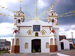
The church of San Nicolás de Tolentino in the municipal seat dates from the 17th century.
References
- "Estado de Tlaxcala-Estacion: Terrenate". Normales Climatologicas 1951–2010 (in Spanish). Servicio Meteorologico Nacional. Retrieved 27 April 2015.
External links
| Wikimedia Commons has media related to Terrenate Municipality. |