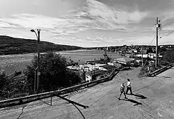
The Battery, St. John's
The Battery is a small neighbourhood within the city of St. John's, Newfoundland and Labrador.
The Battery | |
|---|---|
Neighbourhood | |
 | |
| Country | |
| Province | |
| City | St. John's |
| Ward | 2 |
| Government | |
| • Administrative body | St. John's City Council |
| • Councilor | Shawn Skinner |
The Battery sits on the entrance to the harbour located on the slopes of Signal Hill. Sometimes described as an outport within the city of St. John's. The area is noted for its steep slopes, colourful houses, and its importance as a battery for the defence of St. John's Harbour in both World Wars.
The Battery is home to Chain Rock, a land outcropping to which a large chain and anti-submarine boom were attached connecting to Fort Amherst in order to prevent the entry of German U-boats into the harbour during World War II. Chain Rock is one of two rocks located on opposite sides of the Narrows, Chain Rock on the battery side and Pancake Rock on the opposite. The space between the two rocks is 174 metres. Chain Rock and Pancake Rock were used as early as 1770.[1] A defensive chain was stretched between the rocks by means of a capstan at nightfall to prevent illegal entry of enemy ships. During World War I, the chain was replaced with anti-submarine nets.
Another historic property in the area is Anderson House located at 42 Powers Court in the Battery, which is believed to be the oldest structure in the city of St. John's.[2]
Slope instability
While there have been only three major cases of recorded slope instability in The Battery, archived reports and evidence suggest that minor landslides, and a small number of avalanches, have been frequent in the area's past. A list of notable incidents of slope instability resulting in injury or death includes:[3]
| Date of avalanche | Homes destroyed | Human losses |
|---|---|---|
| February 8, 1921 | One occupied; numerous unoccupied | Two severe injuries |
| February 18, 1921 | One home destroyed | One death |
| February 16, 1959 | Two homes destroyed | Five deaths; multiple injuries |
| January 17, 2020[4] | One home damaged | None |
Although no major events have occurred between 1959 and 2020, in 1995 the city of St. John's began studying the area in an attempt to minimize risk associated with rock slides and avalanches. The Canadian Avalanche Association conducted studies in the area; based on their work, the city spent an estimated $300,000 to protect the area from further instability.[5]


Notables
- Frank Maher (musician), button accordionist
References
- Encyclopedia of Newfoundland and Labrador, Volume one, page 395, 396
- St. John's: Anderson House, Newfoundland and Labrador Heritage Site; Memorial University of Newfoundland http://www.heritage.nf.ca/society/rhs/rs_listing/136.html
- The Assessment of Geological Hazards and Disasters in Newfoundland: An Update. (St. John's: Government of Newfoundland and Labrador, Department of Mines and Energy, Geological Survey) http://www.nr.gov.nl.ca/mines&en/geosurvey/publications/cr1999/batterson.pdf
- "Avalanche hits one home in St. John's Battery". The Telegram. January 17, 2020. Retrieved January 17, 2020.
- The Battery - A Case Study; Newfoundland and Labrador Heritage Site; Memorial University of Newfoundland http://www.heritage.nf.ca/environment/battery.html
| Government | |
|---|---|
| Geography | |
| Sports | |
| Culture | |
| Transportation | |
| |