Thomas Harrison (surveyor)
Thomas Harrison (c. 1823-1894) was the first Government Surveyor of Jamaica. His maps have become an important historical resource for the island.[1]
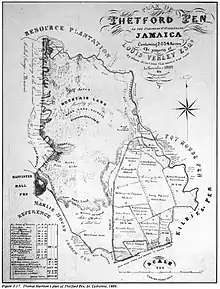
Plan of Thetford Pen in the Parish of St. Catherine &c. Thomas Harrison, 1889.
He was apprenticed to Edward McGeachy.[2]
References
- Higman, B. W. (2001). Jamaica Surveyed: Plantation Maps and Plans of the Eighteenth and Nineteenth Centuries. Kingston: University of the West Indies Press. pp. 43–48. ISBN 978-976-640-113-9.
- "Jamaica Land Surveying Before the Survey Department", B. W. Higman, Jamaica Journal, Vol. 21, No. 2 (May-July 1988), pp. 21-27. Digital Library of the Caribbean.
This article is issued from Wikipedia. The text is licensed under Creative Commons - Attribution - Sharealike. Additional terms may apply for the media files.