Three Sisters (Northern Cape)
The Three Sisters are a land formation near Victoria West, Northern Cape, South Africa, comprising three distinctively shaped hills. The farm on which they are situated and the nearby railway siding are also named Three Sisters.
| Three Sisters | |
|---|---|
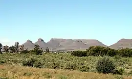 The Three Sisters (with other mountains in the background) | |
| Highest point | |
| Elevation | 1,492 m (4,895 ft) |
| Coordinates | 31°53′41″S 23°8′46″E |
| Geography | |
| Location | Ubuntu Local Municipality, Northern Cape, South Africa |
| Topo map | 3123CC |
The hills (or "koppies" as they are known locally) are topped with dolorite, and are nearly identical in appearance. They can be seen just to the east of the N1 highway, roughly 75 kilometres (47 mi) outside Beaufort West, north of the junction of the N1 and the N12 highways. Due to the open and mountainous Karoo scenery, the area has become a relatively well-known landmark.[1]
There is a large "Shell Ultra City" branded full service petrol station nearby.[2]
The early expansion of the Cape Colony's railway system, planned by the government of Prime Minister John Molteno and driven by Cape Government Railways, saw the Main Western Line to Kimberley pass this formation. A small station was built here in 1881 and it serviced the enormous tracts of farmland in the surrounding districts.[3]
References
- "THREE SISTERS Attractions". Sa-venues.com. Retrieved 2012-06-06.
- "Three Sisters Shell Ultra City - Map and GPS Coordinate finder". Gps-data-team.com. Retrieved 2013-01-17.
- Burman, Jose (1984). Early Railways at the Cape. Cape Town: Human & Rousseau. p. 8. ISBN 0-7981-1760-5.