Thung Khao Luang District
Thung Khao Luang (Thai: ทุ่งเขาหลวง, pronounced [tʰûŋ kʰǎw lǔa̯ŋ]) is a district (amphoe) of Roi Et Province, Thailand.
Thung Khao Luang
ทุ่งเขาหลวง | |
|---|---|
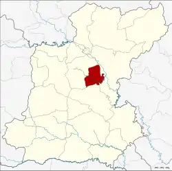 District location in Roi Et Province | |
| Coordinates: 15°59′32″N 103°51′33″E | |
| Country | Thailand |
| Province | Roi Et |
| Seat | Thung Khao Luang |
| Area | |
| • Total | 138.9 km2 (53.6 sq mi) |
| Population (2005) | |
| • Total | 24,260 |
| • Density | 174.7/km2 (452/sq mi) |
| Time zone | UTC+7 (ICT) |
| Postal code | 45170 |
| Geocode | 4520 |
Geography
The district is in central Roi Et Province. Neighboring districts are (from the south clockwise): At Samat, Thawat Buri, and Selaphum.
The important water resource is the Chi River.
History
The minor district was created on 1 July 1997, when the four tambons Thung Khao Luang, Thoet Thai, Bueng Ngam, and Maba were split off from Thawat Buri District.[1]
The Thai government on 15 May 2007 upgraded all of 81 minor districts to full districts.[2] With publication in the Royal Gazette on 24 August, the upgrade became official.[3]
Administration
The district is divided into five sub-districts (tambons), which are further subdivided into 50 villages (mubans). There are no municipal (thesaban) areas. There are five tambon administrative organization (TAO).
| No. | Name | Thai name | Villages | Pop. | |
|---|---|---|---|---|---|
| 1. | Thung Khao Luang | ทุ่งเขาหลวง | 7 | 4,632 | |
| 2. | Thoet Thai | เทอดไทย | 10 | 4,753 | |
| 3. | Bueng Ngam | บึงงาม | 13 | 4,630 | |
| 4. | Maba | มะบ้า | 9 | 4,859 | |
| 5. | Lao | เหล่า | 11 | 5,386 |
Economy
The largely agricultural local economy is augmented by remittances from local women who married foreigners and live abroad. In Ban Jaan (บ้านจาร) village, a settlement of 540 households, at least 100 households have a Western son-in-law, mostly Swiss, leading the town to be known among Thais as the "Swiss village".[4] Local officials claim the number of resident Swiss is overstated as most live with their wives in Switzerland.[5]
References
- ประกาศกระทรวงมหาดไทย เรื่อง แบ่งเขตท้องที่อำเภอธวัชบุรี จังหวัดร้อยเอ็ด ตั้งเป็นกิ่งอำเภอทุ่งเขาหลวง (PDF). Royal Gazette (in Thai). 114 (Special 51 ง): 17. June 25, 1997.
- แถลงผลการประชุม ครม. ประจำวันที่ 15 พ.ค. 2550 (in Thai). Manager Online. Archived from the original on 2011-05-16.
- พระราชกฤษฎีกาตั้งอำเภอฆ้องชัย...และอำเภอเหล่าเสือโก้ก พ.ศ. ๒๕๕๐ (PDF). Royal Gazette (in Thai). 124 (46 ก): 14–21. August 24, 2007.
- Montlake, Simon (20 July 2004). "Thailand's 'Swiss village'". BBC News. Retrieved 17 July 2016.
- Yongcharoenchai, Chaiyot (5 March 2017). "Tied in a knot: the Thai wives who go abroad" (Special Report in Spectrum). Bangkok Post. Retrieved 5 March 2017.