Timmins
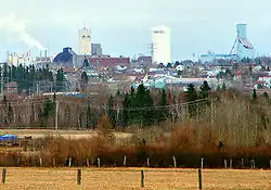
Timmins (/ˈtɪmɪns/ TIM-ins) is a city in northeastern Ontario, Canada, located on the Mattagami River. The city is the fourth-largest city in the Northeastern Ontario region with a population of 41,788 (2016).[3] The city's economy is based on natural resource extraction and is supported by industries related to lumbering and to the mining of gold, zinc, copper, nickel and silver. Timmins serves as a regional service and distribution centre. The city has a large Francophone community, with more than 50% bilingual in French and English.[4]
Timmins | |
|---|---|
| City of Timmins | |
 Timmins, Ontario, Canada | |
 Seal Community Logo | |
| Motto(s): The City with a Heart of Gold | |
 | |
| Coordinates: 48°28′N 81°20′W | |
| Country | Canada |
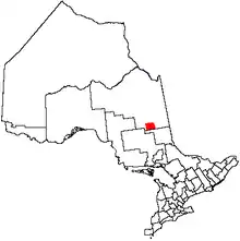
| Province | Ontario |
| District | Cochrane |
| Established | 1912 |
| Named for | Henry Timmins and Noah Timmins |
| Government | |
| • Mayor | George Pirie |
| • Governing Body | Timmins City Council |
| • MPs | Charlie Angus (NDP) |
| • MPPs | Gilles Bisson (ONDP) |
| Area | |
| • Land | 2,978.83 km2 (1,150.13 sq mi) |
| Elevation | 294.70 m (966.86 ft) |
| Population (2016)[1] | |
| • Total | 41,788 |
| • Density | 14/km2 (40/sq mi) |
| Time zone | UTC−5 (EST) |
| • Summer (DST) | UTC−4 (EDT) |
| Forward sortation area | P4N to P4R |
| Area codes | 705 and 249 |
| Website | www |
History
Research performed by archaeologists indicate that human settlement in the area is at least 6,000 years old; it's believed the oldest traces found are from a nomadic people of the Shield Archaic culture.[5][6][7]
Up until contact with settlers, the land belonged to the Mattagami First Nation peoples. Treaty Number Nine of 1906 pushed this tribe to the north side of the Mattagami Lake, the site of a Hudson's Bay trading post first established in 1794.[8] In the 1950s, the reserve was relocated to the south side of the lake, to its present-day location.[7][9]
Gold Mines
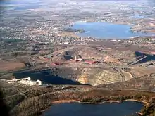
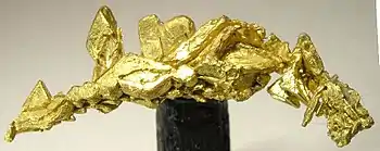
Gold discoveries in the Porcupine Camp during the early years of the 20th Century attracted investors to the area.
According to local folklore, on June 9, 1909, Harry Preston slipped on a rocky knoll and the heels of his boots stripped the moss to reveal a large vein of gold, which later became the Dome Mine. Another theory on how gold was discovered in the Timmins region is that an Indigenous man led Harry Preston to the location where he knew gold would be found. These, however, are only folklore commonly known by citizens of Timmins. A historically accurate account of the very first gold discovery in the area remains unknown.
On October 9, 1909, Benny Hollinger discovered the gold-bearing quartz dike that later became known as the Hollinger Mines.[10] Brothers Noah Timmins and Henry Timmins bought Benny Hollinger's share from him, thus partnering with Hollinger's employers, the McMartin brothers.
On the same day as the Hollinger discovery, Sandy McIntyre discovered the McIntyre Mine near Pearl Lake, four miles away.[11][12] These mines are known as the "Big Three".
Hollinger Mines was incorporated in 1910 with five equal partners consisting of former Mattawa, Ontario, shopkeeper brothers, Noah and Henry Timmins; Duncan and John McMartin, also brothers; and Mattawa attorney David Alexander Dunlapes (1863–1924).[13]
In November 1912, 1,200 members of the Western Federation of Miners Local 145 held a strike at all three mines in response to a proposal to lower their wages.[14] Mine operators hired gun thugs, who fired on the picket line and were ordered out by the provincial government.[15] After months without work, many men chose to leave the settlement; only 500 miners returned to work in July 1913.[14] The strike won the men a nine-hour workday and a pay increase.[14]
The Great Depression did not adversely affect the economy of the area, and jobs were available in mining and lumber.
The gold mines declined in the 1950s.[16]
Settlement
The area became home to dozens of prospectors during the "Porcupine Gold Rush", who explored the areas around Porcupine Lake and the Frederick House River. Rich ore deposits in the Canadian Shield led to Timmins being founded as a company town to house Hollinger employees. In 1912, mine manager Alphonse "Al" Paré named the mining settlement for his uncle, Noah Timmins, who was President of Hollinger Mines.[17] Most settlers grouped around Porcupine Lake and the Dome, one mile from the lake. Four miles down the road, around the McIntyre Mine, the hamlet of Schumacher was established.[16]
The rail system that began to operate around Timmins in 1911 accelerated the growth of the camp. That same year, two days after the first train arrived in the Porcupine, the entire camp was destroyed in the fire of 1911, although the area was rebuilt within two months.
In 1917, a dam was built at Kenogamissi Falls, downriver from Mattagami Lake, to provide power for the Timmins-Porcupine mining camp; Mattagami Lake was consequently flooded.[7]
In 1973, 35 townships covering 1,260 square mile, including Porcupine, South Porcupine, Schumacher, and Timmins were organized into the City of Timmins.[17]:140
In the 1990s, the City of Timmins became a regional service and distribution centre for Northeastern Ontario.[16]
Climate
Timmins is near the northern periphery of the hemiboreal humid continental climate (Dfb). Timmins has very cold winters, being in northern Ontario, but temperatures in late summer and autumn tend to be among the coldest for any major city in any Canadian province, although during the spring and summer it can get hot. The highest temperature ever recorded in Timmins was 39.4 °C (103 °F) on 12 July 1936.[18] The coldest temperature ever recorded was −45.6 °C (−50 °F) on 1 February 1962.[2]
| Climate data for Timmins (Victor Power Airport), 1981−2010 normals, extremes 1922−present[lower-alpha 1] | |||||||||||||
|---|---|---|---|---|---|---|---|---|---|---|---|---|---|
| Month | Jan | Feb | Mar | Apr | May | Jun | Jul | Aug | Sep | Oct | Nov | Dec | Year |
| Record high °C (°F) | 8.0 (46.4) |
12.2 (54.0) |
27.5 (81.5) |
29.9 (85.8) |
34.9 (94.8) |
38.8 (101.8) |
39.4 (102.9) |
36.7 (98.1) |
36.1 (97.0) |
28.9 (84.0) |
20.0 (68.0) |
14.2 (57.6) |
39.4 (102.9) |
| Average high °C (°F) | −10.6 (12.9) |
−7.2 (19.0) |
−0.6 (30.9) |
8.0 (46.4) |
16.6 (61.9) |
21.9 (71.4) |
24.2 (75.6) |
22.5 (72.5) |
17.1 (62.8) |
9.0 (48.2) |
0.6 (33.1) |
−6.9 (19.6) |
7.9 (46.2) |
| Daily mean °C (°F) | −16.8 (1.8) |
−14 (7) |
−7.4 (18.7) |
1.8 (35.2) |
9.6 (49.3) |
14.9 (58.8) |
17.5 (63.5) |
16.0 (60.8) |
11.1 (52.0) |
4.4 (39.9) |
−3.4 (25.9) |
−11.9 (10.6) |
1.8 (35.2) |
| Average low °C (°F) | −23 (−9) |
−20.7 (−5.3) |
−14.2 (6.4) |
−4.5 (23.9) |
2.5 (36.5) |
7.8 (46.0) |
10.7 (51.3) |
9.4 (48.9) |
5.2 (41.4) |
−0.3 (31.5) |
−7.4 (18.7) |
−17 (1) |
−4.3 (24.3) |
| Record low °C (°F) | −44.2 (−47.6) |
−45.6 (−50.1) |
−37.8 (−36.0) |
−29.4 (−20.9) |
−13.9 (7.0) |
−5.6 (21.9) |
−0.5 (31.1) |
−3.3 (26.1) |
−6.4 (20.5) |
−13 (9) |
−33.9 (−29.0) |
−43.9 (−47.0) |
−45.6 (−50.1) |
| Average precipitation mm (inches) | 51.8 (2.04) |
41.3 (1.63) |
54.5 (2.15) |
56.2 (2.21) |
67.4 (2.65) |
83.4 (3.28) |
90.9 (3.58) |
81.6 (3.21) |
84.7 (3.33) |
82.5 (3.25) |
75.9 (2.99) |
64.5 (2.54) |
834.6 (32.86) |
| Average rainfall mm (inches) | 3.2 (0.13) |
1.7 (0.07) |
14.1 (0.56) |
30.1 (1.19) |
62.3 (2.45) |
83.2 (3.28) |
90.9 (3.58) |
81.6 (3.21) |
83.7 (3.30) |
68.1 (2.68) |
30.9 (1.22) |
8.5 (0.33) |
558.3 (21.98) |
| Average snowfall cm (inches) | 57.8 (22.8) |
45.9 (18.1) |
44.8 (17.6) |
27.2 (10.7) |
5.0 (2.0) |
0.2 (0.1) |
0.0 (0.0) |
0.0 (0.0) |
1.0 (0.4) |
15.1 (5.9) |
49.0 (19.3) |
65.2 (25.7) |
311.3 (122.6) |
| Average precipitation days (≥ 0.2 mm) | 17.5 | 14.0 | 13.5 | 11.1 | 12.6 | 14.7 | 14.4 | 14.3 | 15.8 | 16.5 | 19.3 | 19.8 | 183.6 |
| Average rainy days (≥ 0.2 mm) | 1.6 | 1.1 | 3.7 | 6.9 | 11.7 | 14.7 | 14.4 | 14.3 | 15.6 | 13.5 | 6.9 | 2.7 | 107.2 |
| Average snowy days (≥ 0.2 cm) | 17.7 | 14.0 | 11.8 | 6.6 | 2.1 | 0.14 | 0.0 | 0.0 | 0.62 | 5.9 | 15.5 | 19.3 | 93.5 |
| Source: Environment Canada[2][19][20] | |||||||||||||
Demographics
| Year | Pop. | ±% |
|---|---|---|
| 1912 | 974 | — |
| 1921 | 3,843 | +294.6% |
| 1931 | 14,200 | +269.5% |
| 1941 | 28,544 | +101.0% |
| 1951 | 27,743 | −2.8% |
| 1961 | 29,270 | +5.5% |
| 1971 | 28,542 | −2.5% |
| 1981 | 46,114 | +61.6% |
| 1991 | 47,461 | +2.9% |
| 1996 | 47,499 | +0.1% |
| 2001 | 43,686 | −8.0% |
| 2006 | 42,997 | −1.6% |
| 2011 | 43,165 | +0.4% |
| 2016 | 41,788 | −3.2% |
| Canada 2016 Census | Population | % of Total Population | |
|---|---|---|---|
| European Canadian | 36,397 | 87.1 | |
| Visible minority Source:[21] |
African and Caribbean | 185 | 0.4 |
| South Asian | 160 | 0.4 | |
| Filipino | 135 | 0.3 | |
| Chinese | 125 | 0.3 | |
| Latin American | 75 | 0.2 | |
| Southeast Asian | 30 | 0.1 | |
| Other visible minority | 95 | 0.2 | |
| Total visible minority population | 785 | 1.9 | |
| Aboriginal group Source:[21] |
Métis | 2,305 | 5.5 |
| First Nations | 2,245 | 5.4 | |
| Inuit | 50 | 0.1 | |
| Total Aboriginal population | 4,715 | 11 | |
| Total population | 41,788 | 100 | |
| Canada census – Timmins community profile | |||
|---|---|---|---|
| 2016 | 2011 | 2006 | |
| Population: | 41,788 (−3.2% from 2011) | 43,165 (0.4% from 2006) | 42,997 (−1.6% from 2001) |
| Land area: | 2,978.83 km2 (1,150.13 sq mi) | 2,979.15 km2 (1,150.26 sq mi) | 2,961.58 km2 (1,143.47 sq mi) |
| Population density: | 14.0/km2 (36/sq mi) | 14.5/km2 (38/sq mi) | 14.5/km2 (38/sq mi) |
| Median age: | 39.6 (M: 39.0, F: 40.3) | ||
| Total private dwellings: | 19,317 | 18,806 | 18,642 |
| Median household income: | $55,623 | ||
| References: 2016[22] 2011[23] 2006[24] earlier[25] | |||
Language
In Timmins, according to the 2016 census, 63.7% of the population reported English as their first language (Anglophone), 35.6% reported French (Francophone) as their first language, and 0.12% reported a non-official language, neither English nor French, as their first language (Allophone).[26] 50.8% of the population is bilingual in English and French.[4]
Arts and culture
Tourism
Some of the main tourist attractions within the city include: The Timmins Museum and National Exhibition Centre, Cedar Meadows Wilderness Tours, Kamiskotia Snow Resort, Porcupine Ski Runners Cross-Country Trails and Chalet, Hollinger Golf Club, Spruce Needles Golf Club, the Sandy Falls Golf Club, the McIntyre Community Building and the Timmins Snowmobile Club.[27] Snowmobiling impacts the Timmins economy as tourists travel from all over North America to explore area trails.[28]
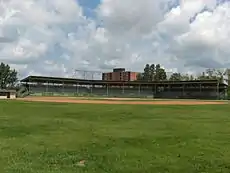
Hollinger Park is one of the city's main recreational spaces. The park is divided in two sections, the north side being the public park area, with the south side having a regulation sized baseball diamond and two soccer fields for more organized outdoor recreational endeavours. The baseball park has been home to the Timmins Men's Baseball League since 1985. Former Timmins resident Shania Twain played a concert at Hollinger Park on July 1, 1999. An estimated 22,000 people attended the outdoor concert.[29][30]
The Pioneer Museum is located 39.5 km (24.5 mi) northeast of the city centre in Connaught, a community of 400 people. Nearby communities include Barbers Bay, Dugwal, Finn Road, Hoyle, Ice Chest Lake, McIntosh Springs and Nighthawk. Local history in the area dates back over 300 years.[31]
La Galeruche Art Gallery, located at 32 Mountjoy Street North (Centre Culturel La Ronde), provides local francophone artists with a venue to exhibit and sell their work.[31]
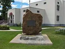
The Porcupine Miner's Memorial tribute is a statue of the miner, head frame and tablets bearing the names of 594 miners killed in mining accidents were unveiled in 2008. The following year, the statues of a mother and two children were unveiled to commemorate those families left behind.[31]
The Timmins Public Library was constructed in 2005 with locally manufactured products, using wood as the main structural material, making efficient use of our natural resources while reducing construction waste. The eco-friendly design was recognized by the Green Building Initiative and the building achieved a 3 Green Globes rating for its efficient use of resources and sustainable development.[31]
Government
The city's mayor is George Pirire.[32] He was sworn in on December 4, 2018, succeeding Steve Black.
Eight councillors serve with the mayor to complete the municipal government. Those eight councilors are elected to one of five areas of the city through a ward electoral system; rural parts of the city elect one councilor each, while the urban core of the city elects four at-large councilors. Councillors are elected to a four-year term.[33]
Timmins City Council
- Rock Whissell, Ward 1 Councillor
- Mickey Auger, Ward 2 Councillor
- Joe Campbell, Ward 3 Councillor
- John P. Curley, Ward 4 Councillor
- Michelle Boileau, Ward 5 Councillor
- Andrew Marks, Ward 5 Councillor
- Kristin Murray, Ward 5 Councillor
- Cory Robin, Ward 5 Councillor
Provincial
The city is currently represented by MPP Gilles Bisson. Bisson also serves as the House Leader[34] for the official opposition. He has served the Timmins area for 29 years, being first elected in 1990.
Federal
The Member of Parliament for Timmins-James Bay is currently Charlie Angus.
Education
Postsecondary education
The two main postsecondary institutions in Timmins is Northern College, a College of Applied Arts and Technology and Collège Boréal, which also has a sister campus of Université de Hearst.[35] Algoma University also offers degrees in Social Work and Community Development on the Northern College Campus in South Porcupine.
School boards
Four school boards serve the City of Timmins:[35]
Media
In 1952, broadcast pioneer J. Conrad Lavigne launched CFCL, the first French-language radio station in Ontario. Prior to the introduction of cable television to the Timmins area in the latter part of the 1970s, the city's available TV channels consisted of English-language channel 3 broadcast out of Sudbury and CFCL's channel 6 (in English) and channel 9 (in French) broadcast from CFCL's studio located at the north end of Cedar Street.
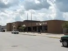
The Timmins Daily Press is the main English publication, publishing six issues per week. Other French-language media include newspapers Le Voyageur and Le Journal L'Express de Timmins.[4]
Healthcare
Timmins and District Hospital (TADH) is an accredited referral and teaching hospital that serves Timmins, Cochrane District, Temiskaming, Sudbury and Algoma Districts.[36] Weeneebayko Area Health Authority also use TADH to transfer patients requiring more advance care not available in their community health care centres.
The 134-bed hospital was formed in 1988 from the merger of St. Mary's General Hospital and Porcupine General Hospital. The two former hospitals were replaced in 1996 and 1993, respectively, when the current site was built.
Sports
The Timmins Rock of the Northern Ontario Junior Hockey League represent Timmins in hockey. They are the city's junior A team. And their affiliate, Timmins Majors, of the Great North Midget League, are the Midget AAA team. They both play at the McIntyre Arena.
Transportation
Timmins Victor M. Power Airport is the main regional airport for the Timmins area. Regional ground transportation is provided by Ontario Northland Motor Coach Services operating out of the Timmins Transit Terminal.[37] The nearest communities with train service are more than 100 kilometers away. They include Foleyet to the west and Gogama to the south on Via Rail's Canadian train line. To the north of Timmins, Cochrane is the southern terminus of the Ontario Northland Railway Polar Bear Express. Matheson and Porquis Junction were formerly the closest stations to the city. Local transit is provided by Timmins Transit.
Notable people
- Alfred Aho, computer scientist, member of US National Academies, professor at Columbia University
- Charlie Angus, musician and songwriter for the band Grievous Angels, now serving as the New Democratic Party Member of Parliament for Timmins—James Bay
- Paul Bellini, comedy writer and television actor
- Gilles Bisson, Ontario New Democratic Party Member of Provincial Parliament for Timmins—James Bay
- Michael Boisvert, actor
- Natalie Brown, actress
- Dave Carroll and Don Carroll, country/pop/folk band Sons of Maxwell
- Carlo Cattarello, Order of Canada & Queen's Jubilee Medal recipient
- Jamie M. Dagg, film director
- Derek Edwards, comedian
- John Labow, actor and television producer
- Maurice LaMarche, comedian and voice actor
- J. Conrad Lavigne, broadcasting pioneer
- Lights (born Valerie Poxleitner), vocalist, singer-songwriter
- Cecil Linder, actor
- Bruce McCaffrey, Progressive Conservative MPP
- Derek McGrath actor
- Gord Miller, former Environment Commissioner of Ontario
- Alan Pope, former Progressive Conservative MPP
- Jim Prentice, former Premier of Alberta, former Member of Parliament from Calgary and federal cabinet minister
- Myron Scholes, Nobel Prize winning economist
- Philippe Tatartcheff, Swiss-born poet and songwriter notable for writing songs in French with Anna and Kate McGarrigle
- Gordon Thiessen, governor of the Bank of Canada from 1994 to 2001
- Roy Thomson, 1st Baron Thomson of Fleet, newspaper magnate, started his empire in the 1930s with the Timmins Daily Press
- Lola Lemire Tostevin, novelist and poet
- Shania Twain, musician
- Bruce Watson, guitarist with Scottish rock band Big Country
See also: List of mayors of Timmins.
Notable athletes
- Pete Babando, National Hockey League (NHL) hockey player
- Bill Barilko, NHL hockey player and subject of the 1993 Tragically Hip song "Fifty Mission Cap"
- Aldege "Baz" Bastien, NHL goaltender
- Sharon Bruneau, female bodybuilder, fitness competitor, actress and stuntwoman
- Les Costello, NHL hockey player with the Toronto Maple Leafs 1947–49. Later became a Roman Catholic priest in Timmins while continuing to play hockey for the "Flying Fathers"
- Réal Chevrefils, NHL hockey player with the Boston Bruins 1951–59.
- Murray Costello, Hockey Hall of Famer, president of the Canadian Amateur Hockey Association
- Larry Courville, NHL hockey player
- Shean Donovan, NHL hockey player
- Paul Harrison, NHL hockey player
- Alex Henry, NHL hockey player
- Art Hodgins, Ice hockey player, inducted in the British Ice Hockey Hall of Fame
- Mark Katic, NHL hockey player
- Kathy Kreiner, Gold medallist, giant slalom, XIIth Olympic Winter Games, Innsbruck, Austria, 13 February 1976
- Laurie Kreiner, Alpine skiing, XI Olympic Winter Games, XIIth Olympic Winter Games
- Jason Gervais, Athletics discus, Sydney 2000 Summer Olympics
- Denis Lapalme, amputee athlete and Paralympic medalist
- Rick Lessard, NHL hockey player
- T. J. Luxmore, NHL Referee
- Frank Mahovlich, NHL hockey player, Canadian Senator
- Pete Mahovlich, NHL hockey player
- Jim Mair, NHL hockey player
- Hector Marini, NHL hockey player
- Gus Mortson, NHL hockey player
- Bob Nevin, NHL hockey player
- Dave Poulin, NHL hockey player
- Dean Prentice, NHL hockey player
- Eric "Doc" Prentice, NHL hockey player
- Dale Rolfe, NHL hockey player
- Steve Shields, NHL goaltender
- Allan Stanley, NHL hockey player
- Steve Sullivan, NHL hockey player
- Walter Tkaczuk, NHL hockey player
- Eric Vail, NHL hockey player, 1975 Calder Trophy winner
References
- "Census Profile, 2016 Census: Timmins, city [Census subdivision], Ontario and Ontario [Province] (table). Census Profile. 2016 Census. Statistics Canada Catalogue no. 98-316-X2016001. Ottawa. Released February 8, 2017". Statistics Canada. Retrieved March 10, 2017.
- "Timmins Victor Power Airport". Canadian Climate Normals 1981–2010. Environment Canada. Retrieved April 12, 2014.
- Census Profile, 2016 Census. Statistics Canada, February 8, 2017. (Accessed December 6, 2017).
- "Timmins | Vivre en Ontario". www.immigrationfrancophone-ontario.ca. Province of Ontario.
- "Our History | City of Timmins". City of Timmins. Retrieved 2017-01-25.
- Schwimmer, Brian. "shield archaic". www.umanitoba.ca. Retrieved 2017-01-25.
- Pollock, John D. (2006-12-01). "Archaeological and Cultural Heritage Impact: Assessment of the Sandy Falls and Lower Sturgeon Generating Stations Redevelopment Projects Located on the Upper Mattagami River. Report Prepared for Ontario Power Generation Inc". Woodland Heritage Services Ltd. CiteSeerX 10.1.1.501.472. Cite journal requires
|journal=(help) - Branch, Government of Canada; Indigenous and Northern Affairs Canada; Communications. "Treaty Guide to Treaty No. 9 (1905–1906)". www.aadnc-aandc.gc.ca. Retrieved 2017-01-25.
- Branch, Government of Canada; Aboriginal Affairs and Northern Development Canada; Communications. "Treaty Research Report – Treaty No. 9 (1905–1906)". www.aadnc-aandc.gc.ca. Retrieved 2017-01-25.
- "History of Timmins". immigrationtimmins.com. Archived from the original on February 5, 2016. Retrieved 2 May 2016.CS1 maint: unfit URL (link)
- "Founding Fathers". timmins.ca. Retrieved 27 January 2015.
- "McIntyre, Sandy". mininghalloffame.ca. The Mining Hall of Fame. Retrieved 2017-01-25.
- "Timmins, Noah". mininghalloffame.ca. The Mining Hall of Fame. Retrieved 2017-01-25.
- Bachmann, Karen. "Labour movement sparked holiday". Timmins Press. Retrieved 2017-01-25.
- "Company Towns". The Canadian Encyclopedia. Retrieved 20 March 2016.
- "History of Timmins". immigrationtimmins.com. Archived from the original on February 5, 2016. Retrieved 2 May 2016.CS1 maint: unfit URL (link)
- Barnes, Michael (1986). Fortunes in the Ground. Erin, Ontario: The Boston Mills Press. p. 123. ISBN 091978352X.
- "Daily Data Report for July 1936". Canadian Climate Data. Environment Canada. Retrieved 23 September 2016.
- "Timmins". Canadian Climate Data. Environment Canada. Retrieved 23 September 2016.
- "Timmins Climate". Canadian Climate Data. Environment Canada. Retrieved 23 September 2016.
- "Pickering, Ontario (City) Census Subdivision". Community Profiles, Canada 2006 Census. Statistics Canada.
- "2016 Community Profiles". 2016 Canadian Census. Statistics Canada. February 21, 2017. Retrieved 2017-03-16.
- "2011 Community Profiles". 2011 Canadian Census. Statistics Canada. July 5, 2013. Retrieved 2012-02-17.
- "2006 Community Profiles". 2006 Canadian Census. Statistics Canada. March 30, 2011. Retrieved 2012-02-17.
- "2001 Community Profiles". 2001 Canadian Census. Statistics Canada. February 17, 2012.
- "Census agglomeration of Timmins, Ontario". Statistics Canada. Government of Canada. Retrieved 5 August 2015.
- "Timmins Snowmobile Club".
- Moore, Sarah (March 6, 2016). "Snowmobiling capital of the world?". Timmins Press. Retrieved 27 November 2016.
- Autio, Andrew (October 31, 2016). "Huge Timmins festival has taxpayers nervous". BayToday.ca. Retrieved November 27, 2016.
- "Branch News" (PDF). Ontario Branch News (9). Summer 2000.
- "Events & Attractions". tourismtimmins.com. Retrieved 5 February 2016.
- "Mayor's Office". 2018. Retrieved 9 September 2019.
- "Mayor and Council". City of Timmins. Retrieved November 27, 2016.
- "Gilles Bisson | Legislative Assembly of Ontario". www.ola.org. Retrieved 2019-09-27.
- "Education". City of Timmins. Retrieved 27 November 2016.
- https://www.tadh.com/about-tadh
- "Timmins Transit". CPTDB.ca. Retrieved 13 June 2020.
- Climate data was recorded at Timmins from April 1922 to December 1957 and at Timmins Airport from April 1955 to present.
External links
| Wikimedia Commons has media related to Timmins, Ontario. |
| Wikivoyage has a travel guide for Timmins. |
Places adjacent to Timmins | |
|---|---|
| City |  | |
|---|---|---|
| Towns | ||
| Townships | ||
| First Nations | ||
| Indian reserves | ||
| Indian settlements | ||
| Unorganized territories | ||
| Local services boards | ||
| Unincorporated communities | ||
| ||