Tinder Fire
The Tinder Fire was a wildfire in East Clear Creek in Coconino National Forest, 1 1/2 miles northeast of Blue Ridge Reservoir in Arizona in the United States. The fire was caused by an illegal campfire and burned a total of 16,309 acres (66 km2). The fire was 100 percent contained on May 24, 2018.
| Tinder Fire | |
|---|---|
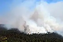 Tinder Fire on April 30, 2018 | |
| Location | Coconino National Forest, Arizona, United States |
| Coordinates | 34.558°N 111.161°W |
| Statistics[1] | |
| Date(s) | April 27, 2018 – May 24, 2018 |
| Burned area | 16,309 acres (66 km2) |
| Cause | Human cause |
| Buildings destroyed | 33 |
| Map | |
 Location of fire in Arizona. | |
Incidents
April
The Tinder Fire was spotted on April 27, 2018 in the East Clear Creek area approximately 1 1/2 miles northeast of Blue Ridge Reservoir.[1] It was spotted by the Coconino National Forest Moqui Lookout at 11:45 am.[2] The fire was fueled by pine, mixed conifer and understory.[1] By April 27, the fire had burned 150 acres (1 km2) of forest. Fire crews arrived on site and by the evening, multiple engines, handcrews, dozers, water tenders air tankers, helicopters and two other aircraft were fighting the fire. By April 27, it was unclear on the cause of the fire.[3]
By the morning of April 29, the fire had grown to 500 acres (2 km2) and a red flag warning was put in place.[4] The fire was approximately nine miles east of Clints Well, Arizona. Select forest roads were closed and evacuation notices were put in place for Moqui Ranch, Moqui Ranchettes and Starlight Pines Ranchettes. Approximately 500 homes northeast of the fire were threatened. Additionally, the East Clear Creek watershed, various protected species, forest road infrastructure, and a riparian zone were also threatened.[2]
By that evening, the fire had ballooned to 8,000 acres (32 km2) due to wind. The first structures were lost in the fire and all communities north, east and west of Arizona State Route 87. Additionally, select portions of the route were closed. Over 500 personnel were fighting the fire, including seven hotshot crews.[5]
May
On the morning of May 1, officials reported that the Tinder Fire had grown to 11,420 acres (46 km2). It remained at zero containment. Firefighters continued to focus on structure protection and mopping up.[6] Later that day, investigators reported that an illegal, abandoned campfire was to blame for the Tinder Fire.[7] The next day, May 2, the fire was declared 12 percent contained at 12,286 acres (50 km2).[8] By the evening of May 3, the fire was 48 percent contained.[9] The Forest Service allowed selective re-entry into evaluation areas on May 4.[10] Arizona governor Doug Ducey declared a state of emergency for Coconino County as a result of the fire.[11]
Route 87 reopened on May 5. The fire was 79 percent contained at 15,841 acres (64 km2), with firefighters patrolling, mopping up and securing the fire lines.[12] Windy conditions continued to cause concern through May 11. On that day, evacuation warnings were put in place for a subdivision of Mogollon Ranch. However, only 100 individuals remained fighting the fire, which remained at 79 percent containment at 16,309 acres (66 km2).[13] The US Forest Service stopped providing daily updates on the Timber Fire on May 12.
By May 24, the fire had been declared 100 percent contained at a total of 16,309 acres (66 km2).[1]
Impact
The Tinder Fire destroyed 33 homes and 54 minor structures.[14]
References
- "Tinder Fire". InciWeb. US Forest Service. Retrieved 30 May 2018.
- "Tinder fire continues to grow; Type I team en route". InciWeb. US Forest Service. Retrieved 31 May 2018.
- "Tinder Fire Update: Wildfire in East Clear Creek". InciWeb. US Forest Service. Retrieved 31 May 2018.
- "Red Flag Warning Today; Tinder Fire Growth Expected". InciWeb. US Forest Service. Retrieved 31 May 2018.
- "Evacuations, Road Closures, and Structures Burned as High Winds Drove Tinde". InciWeb. US Forest Service. Retrieved 31 May 2018.
- "Firefighters Will Continue to Build on Yesterday's Good Progress". InciWeb. US Forest Service. Retrieved 31 May 2018.
- "May 1st News Release From the USFS". InciWeb. US Forest Service. Retrieved 31 May 2018.
- "Precipitation Dampens Fire Activity". InciWeb. US Forest Service. Retrieved 31 May 2018.
- "Limited Fire Activity Today Gives Firefighters a Chance". InciWeb. US Forest Service. Retrieved 31 May 2018.
- "Coconino County to lift Tinder Fire evacuation order for residents Friday". InciWeb. US Forest Service. Retrieved 31 May 2018.
- CNN, Eric Levenson and Amir Vera. "Tinder Fire in Arizona has destroyed 33 homes and is still burning". CNN. Retrieved 31 May 2018.
- "Hwy 87 is open but the Coconino National Forest area closure for the Tinder". InciWeb. US Forest Service. Retrieved 31 May 2018.
- "Tinder fire update: Firefighters staged for structure protection". InciWeb. US Forest Service. Retrieved 31 May 2018.
- "Re-entry into evacuated areas starts today". InciWeb. US Forest Service. Retrieved 31 May 2018.
![]() This article incorporates public domain material from websites or documents of the United States Department of Agriculture.
This article incorporates public domain material from websites or documents of the United States Department of Agriculture.
External links
 Media related to Tinder Fire at Wikimedia Commons