Tirilye
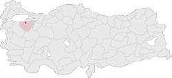
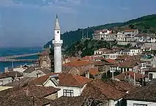
Tirilye (also known as Zeytinbağı) is a town in Bursa Province, Turkey, situated 12 km (7.46 mi) west of Mudanya. It is a country along the Marmara Sealine. The area, which was inhabited since the 8th century BC, was formerly known as Τρίγλεια, Trigleia or Βρύλλειον, Brylleion in Greek. When demand for the products of Southern Marmara from the ancient world increased, ports have been constructed in Kios (Gemlik), Kurşunlu, Apamea Myrlea(Mudanya), Siği (Kumyaka), and Trilye (Zeytinbağı) and the region boomed. The most important historical structure in Trilye (Triglia) is that of the Byzantine Haghioi Theodoroi Church, known today as the Fatih Mosque. Mudanya, a residential and commercial development in this township is under state protection as a historical site.
Tirilye | |
|---|---|
 Location in Turkey | |
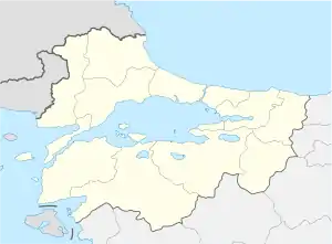 Tirilye Location of Tirilye within the Region of Marmara  Tirilye Location of Tirilyewithin Turkey | |
| Coordinates: 40°23′32″N 28°47′40″E | |
| Country | |
| Region | Marmara |
| Province | Bursa |
| Time zone | UTC+2 (EET) |
| • Summer (DST) | UTC+3 (EEST) |
| Postal code | 16x xx |
| Area code(s) | 0224 |
| Licence plate | 16 |
| Website | www |
Trilye has been an important religious center for Greek Orthodox Christians for a long time. Trilye is a first level protected area since 1980 because of the Byzantine and Ottoman architectural monuments and is considered as an open-air museum thanks to the historical buildings and houses. Osman Gazi’s Turkmens in Bursa and surroundings have started settling in this location from the beginning of the year 1303. Kaymak Oba, Mirza Oba and Çepni villages located at the back of Trilye are believed to have been established during this era. After Mudanya was conquered in 1321 Trilye’s ports and other ports in the region started being used. The land at the western parts of Bursa namely the area between current Minor Industry Area (Küçük Sanayi Bölgesi) and Uluabat Lake were very fertile. Grapes, cocoons and cereal crops were grown in this region. In addition the Tahtalı, Demirci and Doğancı regions had high quality wood used in the production of ships. There are signs proving a Genoese cargo boat has visited Trilye port in the 1330s.
Churches and monasteries were constructed in Trigleia and its surroundings on the patronage of Byzantine Emperors.
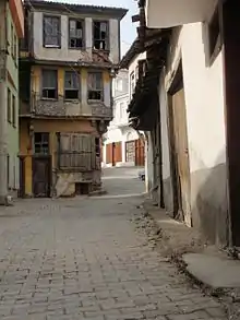
Only 2500 people currently live in the town due to the impact of the 1923 population exchange between Greece and Turkey. Only the ruins of the Byzantines remain, the ruins of old Byzantine churches. Greek houses built at the end of the 19th century prior to the Genocide line the remaining streets. Nevertheless, the town is under the protection of the Ministry of Culture so no one can destroy the old houses or rebuild them in a different style than the original one. The place is known for its olives and had historically been inhabited by Greek artisans engaged in the silk trade. 'Zeytingbagi' means 'olive yard'.
History
The area has been host to various civilizations since antiquity. Tirilye is the original village. Although the name of the village has been officially changed to Zeytinbağı (Olive Orchard), that name is rarely, if ever, used in daily life, and the name Trilye is used instead.
There are several legends about the origins of the name. One is that the area was famous for red mullet and red gurnard and that those fish were the main course of the Byzantine emperors' tables. "Trigleia" (Triglia lucerna) is a word in Greek for such fish.
Another legend comes from the Genoese. Three inhabitants of the village were distressed by the looting of pirates. Therefore, they combined their power and decided to live together. The name Tirilye is said to be derived from those three villagers.
Even after the Ottoman Empire absorbed the area, it remained Greek-populated. Although some Muslims from several areas in Anatolia had settled here the Christian population remained in the majority. During the Greek genocide, the wealthier class of the inhabitants of the village opened their shops and started distributing oil, rice, sugar, etc., to the poor, but were prevented from continuing further distribution by the Government officials.[1] One Church was turned into a Mosque.[1] Houses were demolished.[1]
After the Greco-Turkish War of 1919–1922 and the population exchange between Greece and Turkey that followed the Greeks left the village. The Greeks migrated to Greece with the help of local businessman and ship owner Phillipos Kavounidis. The refugees were taken mainly to two places 1) to Rafina, near Athens, where icons from the churches can currently be seen inside one of the local churches and 2) to Nea Triglia, Chalkidiki. In turn, Muslim immigrants mainly from Salonica (Thessaloniki and Langadas) and other places were settled in Tirilye.
Fatih Mosque
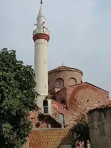
The Fatih Mosque (Turkish: Fatih Camii) is a mosque in Tirilye, which was converted from an 8th-century Byzantine church dedicated to Saint Stefanos (Moni Hinolakou- Μονή Χηνολάκκου). The building was constructed between 720 and 730 AD, originally as the Church of Christ and Saint Stefanos. After the Ottoman conquest of the town, it was converted (in 1661) to a mosque and named "Fatih", which means "conqueror". The mosque was briefly rededicated as a church during the Greek orccupation of the area in the Greco-Turkish War of 1919–1922.
The church is the oldest Byzantine building in the region, and has protected status. It is of the typical Byzantine cross-in-square style and has Byzantine column headings at the entrance and a dome 19 metres (62 feet) high. The mosque is entuered thorough a portico covered with a wooden roof which is standing on four columns that have ornamented metal headings. The building has a mihrab that is covered with a half-dome. It has been declared as a protected monument by 1299/31.8.1990 decision of BURSA KÜLTÜR ve TABİAT VARLIKLARINI KORUMA KURULU BÜRO MÜDÜRLÜĞÜ.
New Stone School (Taş Mektep)
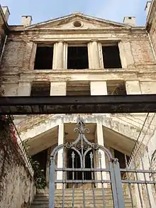
The New Stone School, built on an idea of Metropolitan Chryssostomos, in a markedly neoclassical style, is the largest building in town. The construction of the magnificent building started in 1909 and was completed in three years (1912). It is situated on an area of 965 square metres (10,390 square feet), is four stories high and is located on the hill at the west of İskele Street. In 1924 after the establishment of the republic it is opened as a school called Dar-ül Eytam for orphans, who were the children of soldiers that died in the war. The building served as a boarding school, a primary school and a secondary school later on. The historical building that was evacuated in 1989 was transferred to Uludağ University first and then was transferred to Zeytinbağı Municipality for restorations. It has been declared as a protected monument by 1299/31.8.1990 decision of BURSA KÜLTÜR ve TABİAT VARLIKLARINI KORUMA KURULU BÜRO MÜDÜRLÜĞÜ.
Yperagia Theotokos-Metropolis Church
The complex, which was constructed in Trilye in 1878 as a Greek Church, after 1924 The Dar-ül Eytam School, which opens to the Stone School (being used for the workshops for carpentry and iron works for 400 students), and the “Dündar House", used as a mess house. The church had three vertical lines similar to all other churches(Vertical lines are separated with columns), but the abscissa of the church was demolished for creating a new entrance, causing the upper part of the entrance to be higher than the sides. The Church building was used as a mess hall until the school was closed in September 1927. Due to its function it was called “mess hall” until its restoration, which turned the building into Faruk Çelik Cultural Center. It has been declared as a protected monument by 1299/31.8.1990 decision of BURSA KÜLTÜR ve TABİAT VARLIKLARINI KORUMA KURULU BÜRO MÜDÜRLÜĞÜ. Upon the request of the Greek Culture Delegation a ceremony was held in this building during the visit of the Ecumenical Patriarch of Constantinople Bartholomew I to Tirilye on July 1, 2009. Starting from 2019 "Theofaneia" ceremony is held each year (on 19/1/2019 and 20/1/2020) by Patriarch Bartholomew.
Churches in the city
In Triyle there were seven churches, three monasteries and three holy springs in Zeytinbağı however only four of these churches have survived up until now and are Ayios Stefanos or Moni Hinolakou (Fatih Camii since 1661), Panagia Pantovasilissa (Kemer Kilise), Ayios Georgios Ano (known as Dundar's House) and Virgin Mary-Metropolis. All four have been declared as a protected monuments by 1299/31.8.1990 decision of BURSA KÜLTÜR ve TABİAT VARLIKLARINI KORUMA KURULU BÜRO MÜDÜRLÜĞÜ. Of the monasteries, only Ayios Ioannis Theologos (Pelekete) Monastery has even partially survived among the three monasteries and the area around it has been declared as archeological area by 3996/27.9.2013 decision of the same Bureau. On one of the demolished churches (Ayios Yoannis) has been built the Trilye Town Hall. The ruins of the three monasteries, which were built during the Byzantine era, are out of Trilye. One of these is the Medikion Monastery (Hagios Sergios Monastery) located on the road to Eşkel Village. The monastery was built during the 8th century and is now operated as a farm. Today, all that remains are the perimeter walls, and the magnificent entrance doors, being200 kg (441 lb). The monastery has been declared as a protected monument by 1299/31.8.1990 decision of the same Bureau.The ruin of the second monastery is 5 km (3 mi) far from the town and is called Hagios Ioannis Theologos (Pelekete) Aya Yani Monastery, which is known as the Ayani Ranch by the public. The monastery was built in 709 and used until 1922; only some ruins of the church and walls are remaining today. As said, the area around the monastery has been declared as archeological area by 3996/27.9.2013 decision of the same Bureau. The third ruin is the one of the Vatheos Rhyakos Soterios Monastery known as the Aya Sotiri by the public. Most of the buildings of the monastery are ruined. However, their owners still use some buildings as shelters. Turks, who settled in the area during Yavuz Sultan Selim Time, also built a Turkish bath and a School in 1907. Those structures are regarded as important historical locations, which have also survived into modern day.
Panagia Pantobasilissa (Lady Queen of All) Church
Panagia Pantobasilissa or Arched Church as it is called in the region is known to be the first church where the walls were decorated with frescoes.
It is indicated in some handwritten scripts that the church was dedicated to Panagia Pantobasillissa (Mary Queen of All). The church is based on a Greek cross plan to in the east and west directions. Although the building is not used currently it has still survived. According to the construction style of its walls, it is believed that the building was constructed at the end of the 13th century. The church has pictures on its walls at different layers and is considered to be very important for Christians. The first layer of frescos were made at the start of the 14th century, the second layer of frescos were made in 1723. It is believed that the columns were brought from Alexandria. There are support pillars at the façades and the public calls the building as the Arched Church. It has been declared as a protected monument by 1299/31.8.1990 decision of BURSA KÜLTÜR ve TABİAT VARLIKLARINI KORUMA KURULU BÜRO MÜDÜRLÜĞÜ.
Dündar House
The Agios Georgios Ano Greek Church, which is known as the Dündar House in the region, has been transferred to private property after Greeks abandoned the region. It is located in the north of Taş Mektep (New School built by Metropolitan Chryssostomos 1909-1912). It was reconstructed at the end of the 19th century and has a basilical plan type. The wooden main entrance door in the middle of the western wall has two wings. The door opening is framed by a round arch that sits on the marble pilasters, as well as a rectangular frame consisting of a pilaster on the sides and a two-step lintel at the top. Three-floored western part of the church was used as a residence but currently is closed. There are two windows on each side of the two rows of windows that illuminate the narthex on the sides of this door. The lower row windows are rectangular near the square, the upper row is narrower and longer. There are Byzantine decorations and stone ornaments on its walls.
Monastery of Hagios Sergios
It is located at the beginning of the road that leaves the main road in the south of Tirilye and leads to the land with olive groves. The monastery was established in the late 8th century, and produced some important iconodule figures during the Byzantine Iconoclasm. After that, its history is obscure; it is mentioned in 1054, and it is known that it burned down and was rebuilt in 1800–01, but had fallen into disuse by the end of the 19th century, Today, only the outer wall of the complex survives.
Pelekete monastery
The ruin of the monastery is 5 km (3 mi) far from the town and is called Hagios Ioannes Theologos (Pelekete) Aya Yani Monastery, which is known as the Ayani Ranch by the public. The monastery was built in 709 and used until 1922; only the ruins of the church and walls are remaining today.
Batheos Rhyakos Soteros Monastery
The ruins of the monastery belong to Batheos Rhyakos Soteros Monastery known as the Aya Sotiri by the public. Most of the buildings of the monastery are ruined however their owners use some buildings as shelters.
Christ-Sauveur / Ruissau-Profond Monastery
It was built in 956.[2]
Kapanca Port
The antic port, which is in Kapanca Districts of Trilye, dates back to the Roman era; it was the most important port for transportation during its time. It has been understood that the Genoese have used Trilye and Apemeia (Mudanya) ports for transporting the salt extracted from the northern part of the Appolonia Lake. Trilye was an important port for exporting the goods produced in the fertile lands to the center of the Byzantine Empire.
Swallow's Nest (Historical Pine Teahouse) (Tarihi Çamlı Kahve)
The Historical Pine Coffee lies on a high hill past the Stone School and is referred as the balcony of Trilye. This area is used as a teahouse and overlooks the sea and olive orchards.
Turkish bath
The exact name and construction date is not known of hamam (Turkish Bath) which is located at the same building lot with the Fatih Mosque and in the southern side of it; however, there is information to the effect that it was built by Turks brought from Kastamonu and Üsküdar during Yavuz Sultan Selim's era in the first half of the 16th century.
The building features a rectangular plan schema consisting of five spaces. Its walls were laid with rough stone and brick; in the laying system, typical lighting gaps peculiar to baths were allowed. The space above the göbek taşı (heated marble platform on which one lies to sweat in a Turkish bath) is covered with two small domes. Other spaces are covered with broken-roof. Despite its quite well preserved condition in physical terms, it is not being used today.
International relations
Notable people
- Ismail Akbay (October 17, 1930 – 2003) was the first Turk who worked for NASA.
Footnotes
- Persecution of the Greeks in Turkey, 1914-1918. Constantinople [London, Printed by the Hesperia Press]. 1919.
- http://www.yesilbursadergisi.com/mobil/haber.php?id=321
- Zeytinbağı (Trilye) Rum Misafirlerini Ağırladı (in Turkish)
External links
| Wikimedia Commons has media related to Tirilye. |
| External video | |
|---|---|
- https://web.archive.org/web/20130810165039/http://www.zeytinbagi.bel.tr/
- http://www.pbase.com/sabbilsel/zeytinbag
- http://www.agbursa.com/tirilye/album2.shtml
- https://web.archive.org/web/20120206010926/http://www.istanbulguide.net/picture/triglia.jpg