Tomichi Pass
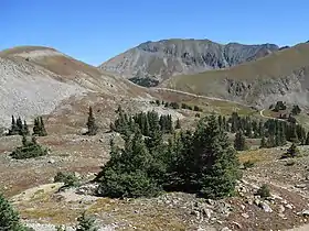
Tomichi Pass (elevation 11,962 feet (3,646 m)) is a high mountain pass in the Sawatch Range of the Rocky Mountains of Colorado. It is located in Gunnison County and in the Gunnison National Forest. The pass divides the watersheds of Middle Quartz Creek to the north and Tomichi Creek to the south.[1][2]
| Tomichi Pass | |
|---|---|
 Tomichi Pass | |
| Elevation | 11,962 ft (3,646 m)[1] |
| Traversed by | Forest Road 888 |
| Location | Gunnison County, Colorado, U.S. |
| Range | Sawatch Range |
| Coordinates | 38°36′13″N 106°23′00″W[1] |
| Topo map | Whitepine |
The pass is traversed by Forest Road 888, which is a four-wheel-drive path and is particularly narrow and exposed on the north side.[2][3]
The pass was originally traversed by a pack trail connecting the mines and mining camps to the north with those to the south in the 1870s. Improvements eventually allowed the passage of wagons, but the road never saw significant traffic.[2][4]
References
- "Tomichi Pass". Geographic Names Information System. United States Geological Survey.
- Helmuth, Ed; Helmuth, Gloria (1994). The Passes of Colorado: An Encyclopedia of Watershed Divides. Boulder, Colorado: Pruett Publishing Company. ISBN 0-87108-841-X.
- "Tomichi Pass Trail". trails.colorado.gov. Retrieved 29 December 2020.
- Vandenbusche, Duane (1980). The Gunnison Country. Gunnison, Colorado: B&B Printers. pp. 394–395. LCCN 80-070455.
External links
- Tomichi Pass, 4x4explore.com
- Tomichi Pass ATV Trail, atvtrails.org
This article is issued from Wikipedia. The text is licensed under Creative Commons - Attribution - Sharealike. Additional terms may apply for the media files.