Torbjørnskjær Lighthouse
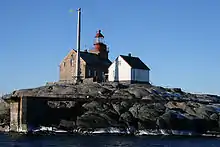
Torbjørnskjær Lighthouse (Norwegian: Torbjørnskjær fyr, Urban East Norwegian: [ˈtʊ̂rbjøːɳʂæːr ˈfyːr]) is a fully automated coastal lighthouse situated on a skerry in the archipelago municipality of Hvaler, Norway. It marks the east side of the entrance to the Oslofjord, with Færder marking the west. The light is powered by solar power. Landing conditions are very difficult, and nowadays service calls are made via helicopter. The lighthouse and surrounding buildings, which include residences, outhouse, a well, and engine house are proposed protected as a national park.
 Torbjørnskjær Lighthouse | |
 Norway South | |
| |
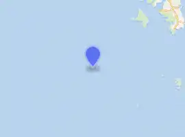
| Location | Hvaler, Viken, Norway |
|---|---|
| Coordinates | 58.995975°N 10.78248°E |
| Year first constructed | 1872 |
| Automated | 1990 |
| Foundation | granite |
| Construction | granite |
| Tower shape | square house with lantern on roof |
| Markings / pattern | unpainted stone house, red lantern |
| Tower height | 17.9 metres (59 ft) |
| Focal height | 25.7 metres (84 ft) |
| Current lens | 3° order Fresnel lens |
| Range | 15 nautical miles (28 km; 17 mi) |
| Characteristic | F Fl W 10s. |
| Admiralty number | B2219 |
| NGA number | 0012 |
| ARLHS number | NOR-046 |
| Norway number | NF-0002[1] |
| Heritage | cultural property |
References
- Torbjørnskjær Lighthouse The Lighthouse Directory. University of North Carolina at Chapel Hill. Retrieved March 10, 2016
- Rowlett, Russ. "Lighthouses of Norway: Oslo Area". The Lighthouse Directory. University of North Carolina at Chapel Hill.
- Ryvarden, Leif; Lauritzen, Per Roger (2006). KystNorge. 1–3. Oslo: Gyldendal. ISBN 978-82-05-35265-0.
External links
- Norsk Fyrhistorisk Forening (in Norwegian)
This article is issued from Wikipedia. The text is licensed under Creative Commons - Attribution - Sharealike. Additional terms may apply for the media files.