Transfer Station Fire
The Transfer Station Fire was a wildfire five miles east of Eagar, Arizona in the United States. The fire, which burned a total of 2,500 acres (10 km2), was reported on October 19, 2017 and 100% contained by the next day, October 20. The fire threatened the city of Eagar and the town of Springerville. It burned less than a mile east of the Springerville Municipal Airport and a nearby laminate facility was evacuated due to the fire threat. The cause of the fire remains unknown.
| Transfer Station Fire | |
|---|---|
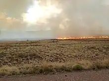 Transfer Station Fire in October 2017 | |
| Location | Eagar, Arizona, United States |
| Coordinates | 34.103°N 109.366°W |
| Statistics[1] | |
| Date(s) | October 19, 2017 – October 20, 2017 |
| Burned area | 2,500 acres (10 km2) |
| Cause | Unknown |
| Map | |
 Location of fire in Arizona. | |
Events
The Transfer Station Fire was reported on October 19, 2017, at 12:30 pm, approximately five miles west of Eagar, Arizona and half a mile east of the Springerville Municipal Airport. The cause of the fire was, and remains, unknown. It was fueled by grass, juniper and pinyon pine. Fire crews from the US Forest Service and local fire departments fought the fire, totaling 50 firefighters. Due to the fire's rapid growth, Arizona Structural Laminators' employees were evacuated. A portion of Arizona State Route 260 was closed.[1] The fire was 70% contained by 5:00 pm and by noon on October 20, the fire was reported 100% contained.[2]
References
- "Transfer Station Fire". InciWeb. US Forest Service. Retrieved 17 December 2017.
- County, Navajo (20 October 2017). "The 2500-acre #TransferStationFire W of Eagar is now 100% contained!SR 260 has reopened at MP". @NavajoCountyAZ. Twitter. Retrieved 18 December 2017.