Transhimalaya
The Transhimalaya (also spelled Trans-Himalaya), or "Gangdise – Nyenchen Tanglha range", is a 1,600-kilometre-long (990 mi) mountain range in China, extending in a west–east direction parallel to the main Himalayan range. Located north of Yarlung Tsangpo river on the southern edge of the Tibetan Plateau, the Transhimalaya is composed of the Gangdise range to the west and the Nyenchen Tanglha range to the east.
| Transhimalaya (Gangdise – Nyenchen Tanglha range, Hedin Mountains) | |
|---|---|
 Part of the Nyenchen Tanglha range in the Trans himalayas | |
| Highest point | |
| Peak | Mount Nyenchen Tanglha |
| Elevation | 7,162 m (23,497 ft) |
| Dimensions | |
| Length | 1,600 km (990 mi) |
| Geography | |
| State | Tibet |
| Range coordinates | 30°23′00″N 90°34′31″E |
| Parent range | Alpine orogeny, Tibetan Plateau (perimeter range) |
The name Trans-Himalaya was introduced by the Swedish geographer Sven Hedin in early 20th century.[1] The Trans-Himalaya was described by the Columbia Lippincott Gazetteer in 1952 as an "ill-defined mountain area" with "no marked crest line or central alignment and no division by rivers." On more-modern maps the Kailas Range (Gangdise or Kang-to-sé Shan) in the west is shown as distinct from the Nyenchen Tanglha range in the east.[2]
Gallery
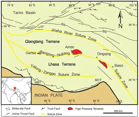 Location of Transhimalaya which includes Lhasa Terrane. In the north, Bangong-Nujiang Suture Zone separates Transhimalaya from the Qiangtang terrane. In the south, Indus-Yarlung suture zone separates it from Himalayas.
 Tectonic map of the Himalaya, modified after Le Fort & Cronin (1988). Red is Transhimalaya. Green is Indus-Yarlung suture zone, north of which lies Lhasa terrane, follow by Bangong-Nujiang Suture Zone and then Qiangtang terrane.
See also
- Transhimalaya, includes the following two
References
Citations
Sources
- Allen, Charles (2013-01-17). A Mountain in Tibet: The Search for Mount Kailas and the Sources of the Great Rivers of Asia. Little, Brown Book Group. ISBN 978-1-4055-2497-1. Retrieved 2015-02-07.CS1 maint: ref=harv (link)