Trujillo metropolitan area (Peru)
The Trujillo Metropolitan Area is the name used to refer to the metropolitan area whose core is the city of Trujillo, capital La Libertad Region, this metropolitan area located on the north coast of Peru, extends over an area of approximately 110,000 has and comprises nine of the eleven districts that make up the province of Trujillo.[1] According to population statistics of INEI, It is the third most populous metropolitan area of Peru.
Trujillo Metropolitan Area | |
|---|---|
 | |
| Coordinates: 8°6′43.2″S 79°1′43.68″W | |
| Country | |
| Region | La Libertad |
| Province | |
| Largest city | |
| District(s) | 1.Trujillo 2.Víctor Larco 3.Moche 4.Huanchaco 5.La Esperanza 6.El Porvenir 7.Florencia de Mora 8.Laredo 9.Salaverry |
| Other Cities | Víctor Larco Moche City Huanchaco Salaverry Laredo |
| Government | |
| • Mayor–council government | Cesar Acuña Peralta (Alliance for Progress) |
| Area | |
| • Total | 410 sq mi (1,100 km2) |
| Population (2017 Census) | |
| • Total | 962,369 |
| • Density | 2,169/sq mi (837/km2) |
| Demonym(s) | Trujillano(a) (in Spanish) |
| Time zone | UTC-5 (PET) |
| Area code(s) | 044 |
| Website | http://www.munitrujillo.gob.pe/ |
| Highest elevation 3937 ft/1,200 m (Campana Mountain, in Huanchaco District). Lowest elevation 0 ft/0 m (sea level) at the Pacific Ocean, Buenos Aires beach, and Moche River estuary waterways. | |
History
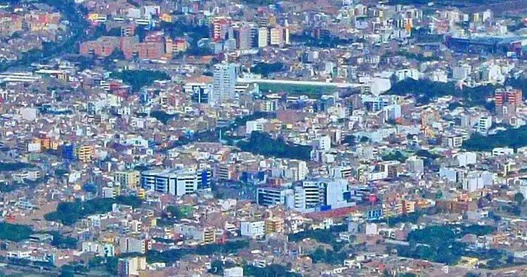
Trujillo, years ago separated from the other localities by the wall Trujillo, is now fully expanded to the four cardinal points of the ancient wall fragments are only historically preserved. However, Trujillo has been influential to nearby cities for decades, having great interaction with them. The urban integration of some of these towns to the metropolis has led its growth. An aerial photograph from the satellite shows a single urban area where it is difficult to distinguish the boundaries of Trujillo and its conurbation metropolitan districts, virtually separated only administratively.
Planning
The Planning of Peruvian metropolitan areas are made, by the government of municipalities of each city, with authority granted by Organic Law of Municipalities, and they have the support of an expert office for urban planning with specific functions. Wherefore officially valid data about districts conformation for metropolitan areas in Peru are those issued by official documents issued and validated by the respective municipal governments of each city under the law that local governments are autonomous political, economic and administrative matters within its jurisdiction and its powers according to the law of municipalities, an attribution of these is to approve the urban development plan.[2]
Extent and structure
The metropolitan area of Trujillo occupies a territory whose length is approximately 110,000 hectares, and comprises the lower Moche Valley or Valle de Santa Catalina and Intervalles to Chicama valley to the north and the Viru Valley southward with its central theme the irrigation project Chavimochic.
Population
According to PLANDET, agency of the Municipality of the city, Metropolitan Trujillo consists of the so-called Trujillo Urban Continuum formed by the districts of Trujillo, El Porvenir, Florencia de Mora, La Esperenza and Victor Larco Herrera, and the sector El Milagro of Huanchaco District, as well as all urban and rural settlements in the valley of Santa Catalina, the Moche river basin, which correspond to the districts of Huanchaco, Laredo, Moche and Salaverry, organized as a unit of planning.
- In the table is shown some data of the districts of Trujillo Metropolitan:
| Ubigeo | District | Homes | Households | Population 2017 |
|---|---|---|---|---|
| 130101 | Trujillo | 87,963 | 82,236 | 314,939 |
| 130102 | El Porvenir | 57,878 | 50,805 | 190,461 |
| 130103 | Florencia De Mora | 7,777 | 8,635 | 37,262 |
| 130104 | Huanchaco | 20,206 | 16,534 | 68,409 |
| 130105 | La Esperanza | 49,773 | 47,896 | 189,206 |
| 130106 | Laredo | 12,204 | 9,933 | 37,206 |
| 130107 | Moche | 9,776 | 8,965 | 37,436 |
| 130109 | Salaverry | 5,599 | 5,244 | 18,944 |
| 130111 | Víctor Larco Herrera | 19,543 | 18,461 | 68,506 |
| TOTAL | 270,719 | 248,709 | 962,369 | |
| Source: National Census 2017 | ||||
- Graphics of evolution of the population by INEI
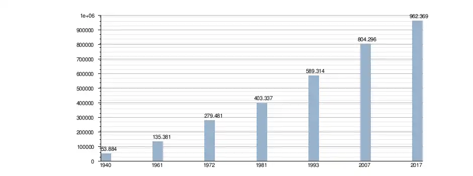
Sources: Population 2007[3]
Population by districts
In the following table of population distribution can be seen the demographic evolution of Trujillo metropolitan by districts.
| Demographic evolution of the Metropolis Trujillo since 1940 | |||||||
| Metropolitan districts of Trujillo [4] | Population by year[5] | ||||||
| 1940 | 1961 | 1972 | 1981 | 1993 | 2007 | Estimated 2015[6] | |
| 1. Trujillo | 45928 | 119221 | 132847 | 202469 | 247028 | 294899 | 318.914 |
| 2. La Esperanza | * | * | 42113 | 62550 | 105361 | 151845 | 182.494 |
| 3. El Porvenir | * | * | 58331 | 77198 | 80698 | 140507 | 186.127 |
| 4. Victor Larco Herrera | * | 4565 | 14140 | 21001 | 42169 | 55781 | 64.024 |
| 5. Huanchaco | 780 | 1087 | 4497 | 7407 | 19935 | 44806 | 68.104 |
| 6. Florencia de Mora | * | * | * | * | 35806 | 40014 | 41.914 |
| 7. Laredo | * | * | 13269 | 15215 | 28019 | 32825 | 35.289 |
| 8. Moche | 3773 | 5903 | 9000 | 11862 | 22020 | 29727 | 34.503 |
| 9. Salaverry | 3403 | 4605 | 5284 | 5635 | 8278 | 13892 | 18.129 |
| Trujillo metropolitan | 53884 | 135381 | 279481 | 403337 | 589314 | 804296 | 909.498 |
| Census made by the INEI[7] Estimated Population-INEI.[8]* The asterisk sign indicates in that year the district had not been created yet. | |||||||
External links
- Location of Trujillo city (Wikimapia)
- "Huaca de la luna and Huaca del sol"
- "Huacas del Sol y de la Luna Archaeological Complex", Official Website
- Information on El Brujo Archaeological Complex
- Chan Chan World Heritage Site, UNESCO
- Chan Chan conservation project
- Website about Trujillo, Reviews, Events, Business Directory
Multimedia
| Wikimedia Commons has media related to Trujillo (Perú). |
- "International Spring Festival in Trujillo" with Miss world 2004 on YouTube
- Tourism in Trujillo city on YouTube
- Marinera Festival 2012 in Trujillo city on YouTube
- Gallery pictures by Panoramio, Includes Geographical information by various authors
References
- PLANDET, strategic plan for comprehensive and sustainable development.
- "(spanish) Law of Municipalities" (PDF). Retrieved 25 October 2012.
- INEI (ed.). "PLAN DE DESARROLLO URBANO METROPOLITANO DE TRUJILLO 2012– 2022".
- (in Spanish)PLANDET (ed.). "Plan estrategico de desarrollo integral y sostenible de Trujillo – Trujillo Metropolitan districts (page 15)" (PDF). Archived from the original (PDF) on 24 September 2015. Retrieved 21 July 2012.
- "Plan of Metropolitan development of Trujillo-Plandet (Pag. 36)" (PDF). Archived from the original (PDF) on 24 September 2015.
- "INEI Population Statistics".
- National Institute of Statistics and Information-Peru http://www.inei.gob.pe/
- "INEI Statistics Population- year 2013".